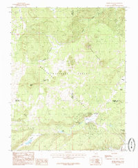
1985 Map of Henrie Knolls
USGS Topo · Published 1985About this map
Dixie National Forest encompasses this high-elevation landscape, where the volcanic and limestone geology of the Markagunt Plateau dictates the movement of water. A notable hydrogeological feature is the Duck Creek Sinks, where surface water from Duck Creek enters subterranean channels, a characteristic of this plateau's karst-like terrain. The map reveals a high-country environment defined by timber and seasonal water sources, including Aspen Mirror Lake, Duck Lake, and numerous named springs like Anderson Spring and Bowers Spring. These water points were critical for livestock and forest management as the region transitioned into a modern recreational and resource area. High points like Henrie Knolls and the Strawberry Knolls overlook a series of high valleys such as Tippets Valley and Red Valley, providing a detailed look at the drainage patterns before they reach the lower basins of southern Utah.
Find a feature on this map
23 named features on this map. Tap any name to fly to it.
Don’t see what you’re looking for? This feature index may not catch every label — zoom into the map to look around manually.
Map Details
Editions of this 1985 Henrie Knolls Map
2 editions found
Other maps of this area

1886 · Kanab
USGS Topo · 1:250,000

1953 · Cedar City
USGS Topo · 1:250,000

1957 · Orderville Canyon NE
USGS Topo · 1:24,000

1958 · Cedar City
USGS Topo · 1:250,000

1958 · Orderville
USGS Topo · 1:62,500

1958 · Cedar Breaks
USGS Topo · 1:62,500

1958 · Panguitch Lake
USGS Topo · 1:62,500

1962 · Cedar City
USGS Topo · 1:250,000
1980 · Straight Canyon
USGS Topo · 1:24,000

1980 · Panguitch
USGS Topo · 1:100,000