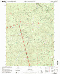
1997 Map of Hopkins Butte
USGS Topo · Published 2001About this map
Schnable Diggings and the Lockharts (Site) anchor this rugged Humboldt County landscape, illustrating a history of remote mountain settlement and resource extraction. The map documents a complex intersection of land management, where the Hoopa Valley Indian Reservation meets the Six Rivers National Forest. Small-scale mining operations like Ferris Mine and the Red Cap Central Mine are plotted among significant topographic features such as Hopkins Butte and LePerron Peak. Drainage systems including South Fork, Red Cap Creek, and Mill Creek carve through the steep terrain, defining the natural corridors that historic trails like the Packsaddle Ridge Trail follow. This late-twentieth-century revision provides an essential record of the boundary lines between tribal lands and the Trinity Alps Wilderness near Colgrove.
Find a feature on this map
42 named features on this map. Tap any name to fly to it.
Don’t see what you’re looking for? This feature index may not catch every label — zoom into the map to look around manually.
Map Details
Editions of this 1997 Hopkins Butte Map
This is the sole edition of this map. No revisions or reprints were ever made.
Other maps of this area

1925 · Hoopa
USGS Topo · 1:125,000

1948 · Weed
USGS Topo · 1:250,000

1950 · Weed
USGS Topo · 1:250,000

1952 · Hoopa
USGS Topo · 1:62,500

1952 · Orleans
USGS Topo · 1:62,500

1955 · Salmon Mtn
USGS Topo · 1:62,500

1955 · Forks of Salmon
USGS Topo · 1:62,500

1958 · Weed
USGS Topo · 1:250,000

1963 · Weed
USGS Topo · 1:250,000

1974 · Orleans Mtn.
USGS Topo · 1:24,000