1969 Map of Capetown
USGS Topo · Published 1974About this map
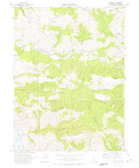
Capetown sits at the heart of this coastal Humboldt County terrain, where the Bear River winds between prominent elevations like Cape Ridge and Bear Ridge. The landscape is defined by a dense network of gulches and creeks, such as Flyblow Gulch and Singley Creek, that feed into the main river valley before it reaches the Pacific Ocean. This 1969 field-checked survey highlights the rural character of the region, emphasizing ranching and land management through features like the Green Pond Ranch and numerous named ridges including Branstetter Ridge and Walker Ridge. The interior is marked by significant topographical landmarks such as Bunker Hill and Twin Peaks, while the presence of a Radio Facility and various Drill Holes points to the mid-century infrastructure and resource exploration present in this part of Northern California.
Find a feature on this map
28 named features on this map. Tap any name to fly to it.
Don’t see what you’re looking for? This feature index may not catch every label — zoom into the map to look around manually.
Map Details
Editions of this 1969 Capetown Map
2 editions found
Historical Maps of Capetown Through Time
341 maps found

1914 Pilot Creek
Humboldt County, CA

1916 Cape Fortunas
Humboldt County, CA

1919 Glynn
Humboldt County, CA

1920 Harris
Humboldt County, CA

1920 Pt. Delagda
Humboldt County, CA

1921 Briceland
Humboldt County, CA

1921 Cape Mendocino
Humboldt County, CA

1921 Dyerville
Humboldt County, CA

1922 China Flat
Humboldt County, CA

1922 Kneeland
Humboldt County, CA

1922 Korbel
Humboldt County, CA

1926 Gorda
Humboldt County, CA

1945 Coyote Peak
Humboldt County, CA

1945 Tectah Creek
Humboldt County, CA

1949 Blocksburg
Humboldt County, CA

1949 Point Delgada
Humboldt County, CA

1950 Cape Mendocino
Humboldt County, CA

1950 Iaqua Buttes
Humboldt County, CA

1951 Blocksburg
Humboldt County, CA

1951 Cape Mendocino
Humboldt County, CA

1951 Pilot Creek
Humboldt County, CA

1951 Point Delgada
Humboldt County, CA

1952 Arcata North
Humboldt County, CA

1952 Coyote Peak
Humboldt County, CA

1952 Orleans
Humboldt County, CA

1952 Tectah Creek
Humboldt County, CA

1959 Arcata North
Humboldt County, CA

1959 Arcata South
Humboldt County, CA

1959 Cannibal Island
Humboldt County, CA

1959 Tyee City
Humboldt County, CA

1966 Crannell
Humboldt County, CA

1966 Fern Canyon
Humboldt County, CA

1966 Rodgers Peak
Humboldt County, CA

1969 Blocksburg
Humboldt County, CA

1969 Briceland
Humboldt County, CA

1969 Bridgeville
Humboldt County, CA

1969 Bull Creek
Humboldt County, CA

1969 Cape Mendocino
Humboldt County, CA

1969 Capetown
Humboldt County, CA

1969 Cooskie Creek
Humboldt County, CA

1969 Ettersburg
Humboldt County, CA

1969 Fort Seward
Humboldt County, CA

1969 Harris
Humboldt County, CA

1969 Jewett Rock
Humboldt County, CA

1969 Petrolia
Humboldt County, CA

1969 Shubrick Peak
Humboldt County, CA

1969 Taylor Peak
Humboldt County, CA

1970 Buckeye Mtn
Humboldt County, CA

1970 Honeydew
Humboldt County, CA

1973 Lord-Ellis Summit
Humboldt County, CA

1974 Fish Lake
Humboldt County, CA

1977 Board Camp Mountain
Humboldt County, CA

1977 Dinsmore
Humboldt County, CA

1977 Larabee Valley
Humboldt County, CA

1977 Mad River Buttes
Humboldt County, CA

1977 Maple Creek
Humboldt County, CA

1978 Black Lassic
Humboldt County, CA

1978 Blake Mountain
Humboldt County, CA

1978 Orleans
Humboldt County, CA

1978 Salmon Mtn.
Humboldt County, CA

1978 Showers Mtn
Humboldt County, CA

1978 Tish Tang Point
Humboldt County, CA

1979 Black Lassic
Humboldt County, CA

1979 Blake Mountain
Humboldt County, CA

1979 Grouse Mtn
Humboldt County, CA

1979 Hennessy Peak
Humboldt County, CA

1979 Hopkins Butte
Humboldt County, CA

1979 Iaqua Buttes
Humboldt County, CA

1979 Korbel
Humboldt County, CA

1979 Mc Whinney Creek
Humboldt County, CA

1979 Owl Creek
Humboldt County, CA

1979 Sims Mountain
Humboldt County, CA

1979 Trinity Mtn
Humboldt County, CA

1979 Yager Junction
Humboldt County, CA

1982 Bald Hills
Humboldt County, CA

1982 Blue Creek Mtn
Humboldt County, CA

1982 Hupa Mountain
Humboldt County, CA

1982 Johnsons
Humboldt County, CA

1982 Panther Creek
Humboldt County, CA

1983 Ah Pah Ridge
Humboldt County, CA

1983 French Camp Ridge
Humboldt County, CA

1983 Holter Ridge
Humboldt County, CA

1989 Cape Mendocino
Humboldt County, CA

1997 Ah Pah Ridge
Humboldt County, CA

1997 Black Lassic
Humboldt County, CA

1997 Blake Mountain
Humboldt County, CA

1997 Blue Creek Mountain
Humboldt County, CA

1997 Board Camp Mountain
Humboldt County, CA

1997 Cooskie Creek
Humboldt County, CA

1997 Dinsmore
Humboldt County, CA

1997 Fish Lake
Humboldt County, CA

1997 Grouse Mountain
Humboldt County, CA

1997 Hennessy Peak
Humboldt County, CA

1997 Hopkins Butte
Humboldt County, CA

1997 Hupa Mountain
Humboldt County, CA

1997 Johnsons
Humboldt County, CA

1997 Lord-Ellis Summit
Humboldt County, CA

1997 Mad River Buttes
Humboldt County, CA

1997 Maple Creek
Humboldt County, CA

1997 Orleans
Humboldt County, CA

1997 Petrolia
Humboldt County, CA

1997 Salmon Mountain
Humboldt County, CA

1997 Showers Mountain
Humboldt County, CA

1997 Shubrick Peak
Humboldt County, CA

1997 Sims Mountain
Humboldt County, CA

1997 Tish Tang Point
Humboldt County, CA

1997 Trinity Mountain
Humboldt County, CA

2012 Ah Pah Ridge
Humboldt County, CA

2012 Arcata North
Humboldt County, CA

2012 Arcata South
Humboldt County, CA

2012 Bald Hills
Humboldt County, CA

2012 Black Lassic
Humboldt County, CA

2012 Blake Mountain
Humboldt County, CA

2012 Blocksburg
Humboldt County, CA

2012 Blue Creek Mountain
Humboldt County, CA

2012 Board Camp Mountain
Humboldt County, CA

2012 Briceland
Humboldt County, CA

2012 Bridgeville
Humboldt County, CA

2012 Buckeye Mountain
Humboldt County, CA

2012 Bull Creek
Humboldt County, CA

2012 Cannibal Island
Humboldt County, CA

2012 Cape Mendocino
Humboldt County, CA

2012 Capetown
Humboldt County, CA

2012 Cooskie Creek
Humboldt County, CA

2012 Crannell
Humboldt County, CA

2012 Dinsmore
Humboldt County, CA

2012 Ettersburg
Humboldt County, CA

2012 Fern Canyon
Humboldt County, CA

2012 Ferndale OE W
Humboldt County, CA

2012 Fish Lake
Humboldt County, CA

2012 Fort Seward
Humboldt County, CA

2012 French Camp Ridge
Humboldt County, CA

2012 Grouse Mountain
Humboldt County, CA

2012 Harris
Humboldt County, CA

2012 Hennessy Peak
Humboldt County, CA

2012 Holter Ridge
Humboldt County, CA

2012 Honeydew
Humboldt County, CA

2012 Hopkins Butte
Humboldt County, CA

2012 Hupa Mountain
Humboldt County, CA

2012 Iaqua Buttes
Humboldt County, CA

2012 Jewett Rock
Humboldt County, CA

2012 Johnsons
Humboldt County, CA

2012 Korbel
Humboldt County, CA

2012 Larabee Valley
Humboldt County, CA

2012 Lord-Ellis Summit
Humboldt County, CA

2012 Mad River Buttes
Humboldt County, CA

2012 Maple Creek
Humboldt County, CA

2012 McWhinney Creek
Humboldt County, CA

2012 Orleans
Humboldt County, CA

2012 Owl Creek
Humboldt County, CA

2012 Panther Creek
Humboldt County, CA

2012 Petrolia
Humboldt County, CA

2012 Rodgers Peak
Humboldt County, CA

2012 Salmon Mountain
Humboldt County, CA

2012 Showers Mountain
Humboldt County, CA

2012 Shubrick Peak
Humboldt County, CA

2012 Shubrick Peak OE S
Humboldt County, CA

2012 Sims Mountain
Humboldt County, CA

2012 Taylor Peak
Humboldt County, CA

2012 Tish Tang Point
Humboldt County, CA

2012 Trinidad OE N
Humboldt County, CA

2012 Trinity Mountain
Humboldt County, CA

2012 Tyee City
Humboldt County, CA

2012 Yager Junction
Humboldt County, CA

2015 Ah Pah Ridge
Humboldt County, CA

2015 Arcata North
Humboldt County, CA

2015 Arcata South
Humboldt County, CA

2015 Bald Hills
Humboldt County, CA

2015 Black Lassic
Humboldt County, CA

2015 Blake Mountain
Humboldt County, CA

2015 Blocksburg
Humboldt County, CA

2015 Blue Creek Mountain
Humboldt County, CA

2015 Board Camp Mountain
Humboldt County, CA

2015 Briceland
Humboldt County, CA

2015 Bridgeville
Humboldt County, CA

2015 Buckeye Mountain
Humboldt County, CA

2015 Bull Creek
Humboldt County, CA

2015 Cannibal Island
Humboldt County, CA

2015 Cape Mendocino
Humboldt County, CA

2015 Capetown
Humboldt County, CA

2015 Cooskie Creek
Humboldt County, CA

2015 Crannell
Humboldt County, CA

2015 Dinsmore
Humboldt County, CA

2015 Ettersburg
Humboldt County, CA

2015 Fern Canyon
Humboldt County, CA

2015 Ferndale OE W
Humboldt County, CA

2015 Fish Lake
Humboldt County, CA

2015 Fort Seward
Humboldt County, CA

2015 French Camp Ridge
Humboldt County, CA

2015 Grouse Mountain
Humboldt County, CA

2015 Harris
Humboldt County, CA

2015 Hennessy Peak
Humboldt County, CA

2015 Holter Ridge
Humboldt County, CA

2015 Honeydew
Humboldt County, CA

2015 Hopkins Butte
Humboldt County, CA

2015 Hupa Mountain
Humboldt County, CA

2015 Iaqua Buttes
Humboldt County, CA

2015 Jewett Rock
Humboldt County, CA

2015 Johnsons
Humboldt County, CA

2015 Korbel
Humboldt County, CA

2015 Larabee Valley
Humboldt County, CA

2015 Lord-Ellis Summit
Humboldt County, CA

2015 Mad River Buttes
Humboldt County, CA

2015 Maple Creek
Humboldt County, CA

2015 McWhinney Creek
Humboldt County, CA

2015 Orleans
Humboldt County, CA

2015 Owl Creek
Humboldt County, CA

2015 Panther Creek
Humboldt County, CA

2015 Petrolia
Humboldt County, CA

2015 Rodgers Peak
Humboldt County, CA

2015 Salmon Mountain
Humboldt County, CA

2015 Showers Mountain
Humboldt County, CA

2015 Shubrick Peak
Humboldt County, CA

2015 Shubrick Peak OE S
Humboldt County, CA

2015 Sims Mountain
Humboldt County, CA

2015 Taylor Peak
Humboldt County, CA

2015 Tish Tang Point
Humboldt County, CA

2015 Trinidad OE N
Humboldt County, CA

2015 Trinity Mountain
Humboldt County, CA

2015 Tyee City
Humboldt County, CA

2015 Yager Junction
Humboldt County, CA

2018 Ah Pah Ridge
Humboldt County, CA

2018 Arcata North
Humboldt County, CA

2018 Arcata South
Humboldt County, CA

2018 Bald Hills
Humboldt County, CA

2018 Black Lassic
Humboldt County, CA

2018 Blake Mountain
Humboldt County, CA

2018 Blocksburg
Humboldt County, CA

2018 Blue Creek Mountain
Humboldt County, CA

2018 Board Camp Mountain
Humboldt County, CA

2018 Briceland
Humboldt County, CA

2018 Bridgeville
Humboldt County, CA

2018 Buckeye Mountain
Humboldt County, CA

2018 Bull Creek
Humboldt County, CA

2018 Cannibal Island
Humboldt County, CA

2018 Cape Mendocino
Humboldt County, CA

2018 Capetown
Humboldt County, CA

2018 Cooskie Creek
Humboldt County, CA

2018 Crannell
Humboldt County, CA

2018 Dinsmore
Humboldt County, CA

2018 Ettersburg
Humboldt County, CA

2018 Fern Canyon
Humboldt County, CA

2018 Ferndale OE W
Humboldt County, CA

2018 Fish Lake
Humboldt County, CA

2018 Fort Seward
Humboldt County, CA

2018 French Camp Ridge
Humboldt County, CA

2018 Grouse Mountain
Humboldt County, CA

2018 Harris
Humboldt County, CA

2018 Hennessy Peak
Humboldt County, CA

2018 Holter Ridge
Humboldt County, CA

2018 Honeydew
Humboldt County, CA

2018 Hopkins Butte
Humboldt County, CA

2018 Hupa Mountain
Humboldt County, CA

2018 Iaqua Buttes
Humboldt County, CA

2018 Jewett Rock
Humboldt County, CA

2018 Johnsons
Humboldt County, CA

2018 Korbel
Humboldt County, CA

2018 Larabee Valley
Humboldt County, CA

2018 Lord-Ellis Summit
Humboldt County, CA

2018 Mad River Buttes
Humboldt County, CA

2018 Maple Creek
Humboldt County, CA

2018 McWhinney Creek
Humboldt County, CA

2018 Orleans
Humboldt County, CA

2018 Owl Creek
Humboldt County, CA

2018 Panther Creek
Humboldt County, CA

2018 Petrolia
Humboldt County, CA

2018 Rodgers Peak
Humboldt County, CA

2018 Salmon Mountain
Humboldt County, CA

2018 Showers Mountain
Humboldt County, CA

2018 Shubrick Peak
Humboldt County, CA

2018 Shubrick Peak OE S
Humboldt County, CA

2018 Sims Mountain
Humboldt County, CA

2018 Taylor Peak
Humboldt County, CA

2018 Tish Tang Point
Humboldt County, CA

2018 Trinidad OE N
Humboldt County, CA

2018 Trinity Mountain
Humboldt County, CA

2018 Tyee City
Humboldt County, CA

2018 Yager Junction
Humboldt County, CA

2021 Ah Pah Ridge
Humboldt County, CA

2021 Arcata North
Humboldt County, CA

2021 Arcata South
Humboldt County, CA

2021 Bald Hills
Humboldt County, CA

2021 Black Lassic
Humboldt County, CA

2021 Blocksburg
Humboldt County, CA

2021 Blue Creek Mountain
Humboldt County, CA

2021 Briceland
Humboldt County, CA

2021 Bridgeville
Humboldt County, CA

2021 Buckeye Mountain
Humboldt County, CA

2021 Bull Creek
Humboldt County, CA

2021 Cape Mendocino
Humboldt County, CA

2021 Capetown
Humboldt County, CA

2021 Cooskie Creek
Humboldt County, CA

2021 Crannell
Humboldt County, CA

2021 Ettersburg
Humboldt County, CA

2021 Fern Canyon
Humboldt County, CA

2021 Ferndale OE W
Humboldt County, CA

2021 Fort Seward
Humboldt County, CA

2021 French Camp Ridge
Humboldt County, CA

2021 Grouse Mountain
Humboldt County, CA

2021 Harris
Humboldt County, CA

2021 Holter Ridge
Humboldt County, CA

2021 Honeydew
Humboldt County, CA

2021 Iaqua Buttes
Humboldt County, CA

2021 Jewett Rock
Humboldt County, CA

2021 Korbel
Humboldt County, CA

2021 Lord-Ellis Summit
Humboldt County, CA

2021 Maple Creek
Humboldt County, CA

2021 McWhinney Creek
Humboldt County, CA

2021 Owl Creek
Humboldt County, CA

2021 Petrolia
Humboldt County, CA

2021 Rodgers Peak
Humboldt County, CA

2021 Showers Mountain
Humboldt County, CA

2021 Shubrick Peak
Humboldt County, CA

2021 Shubrick Peak OE S
Humboldt County, CA

2021 Taylor Peak
Humboldt County, CA

2021 Trinidad OE N
Humboldt County, CA

2021 Tyee City
Humboldt County, CA

2022 Blake Mountain
Humboldt County, CA

2022 Board Camp Mountain
Humboldt County, CA

2022 Cannibal Island
Humboldt County, CA

2022 Dinsmore
Humboldt County, CA

2022 Fish Lake
Humboldt County, CA

2022 Hennessy Peak
Humboldt County, CA

2022 Hopkins Butte
Humboldt County, CA

2022 Hupa Mountain
Humboldt County, CA

2022 Johnsons
Humboldt County, CA

2022 Larabee Valley
Humboldt County, CA

2022 Mad River Buttes
Humboldt County, CA

2022 Orleans
Humboldt County, CA

2022 Panther Creek
Humboldt County, CA

2022 Salmon Mountain
Humboldt County, CA

2022 Sims Mountain
Humboldt County, CA

2022 Tish Tang Point
Humboldt County, CA

2022 Trinity Mountain
Humboldt County, CA

2022 Yager Junction
Humboldt County, CA

2023 Arcata North
Humboldt County, CA

2023 Buckeye Mountain
Humboldt County, CA

2023 Bull Creek
Humboldt County, CA

2023 Harris
Humboldt County, CA

2023 Panther Creek
Humboldt County, CA

2023 Shubrick Peak
Humboldt County, CA