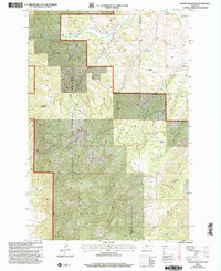
2000 Map of Grassy Mountain
USGS Topo · Published 2005About this map
Gallatin National Forest dominates this mountain landscape at the dawn of the 21st century, revealing a high-altitude wilderness defined by the Bozeman Ranger District and complex county lines between Gallatin and Park counties. The geography is etched with numerous named waterways, including Brackett Creek to the north and the upper reaches of Bridger Creek to the south. A prominent high point, Grassy Mountain, overlooks the drainage of Weasel Creek, while localized administrative history is preserved through labels like the Bangtail Guard Station. Human infrastructure is sparse, restricted to a lone School site in the southwestern corner and several Jeep trails. The map provides a look at the backcountry management of the Gallatin Range, showing how fire and forest administration hubs like Bishop Park were positioned to monitor the drainages of Muddy Creek and North Fork Bridger Creek before modern large-scale development shifted the character of the region.
Find a feature on this map
23 named features on this map. Tap any name to fly to it.
Don’t see what you’re looking for? This feature index may not catch every label — zoom into the map to look around manually.
Map Details
Editions of this 2000 Grassy Mountain Map
This is the sole edition of this map. No revisions or reprints were ever made.
Other maps of this area

1891 · Livingston
USGS Topo · 1:250,000

1893 · Livingston
USGS Topo · 1:250,000

1947 · Bozeman
USGS Topo · 1:250,000

1948 · Bozeman
USGS Topo · 1:250,000

1951 · Bozeman Pass
USGS Topo · 1:62,500

1951 · Gobblers Knob
USGS Topo · 1:24,000

1951 · Hoppers
USGS Topo · 1:24,000
1951 · Wilsall
USGS Topo · 1:24,000

1951 · Sedan
USGS Topo · 1:62,500

1955 · Bozeman
USGS Topo · 1:250,000