
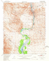
1950 Map of Davis Dam
USGS Topo · Published 1955About this map
The Colorado River serves as the central artery for this mid-century survey, dividing the Black Mountains of Arizona from the desert floor of Nevada and California. The landscape is in the midst of a massive transition following the 1950 completion of Davis Dam, which began the creation of Lake Mohave. While new infrastructure like Bullhead City and Mikes Camp appears on the eastern bank, the map preserves the locations of earlier frontier history, including the Hardyville (Site) and the Fort Mohave (Ruins) located within the Fort Mohave Indian Reservation.
Find a feature on this map
47 named features on this map. Tap any name to fly to it.
Don’t see what you’re looking for? This feature index may not catch every label — zoom into the map to look around manually.
Map Details
Editions of this 1950 Davis Dam Map
2 editions found
Other maps of this area

1886 · Camp Mohave
USGS Topo · 1:250,000

1892 · Camp Mohave
USGS Topo · 1:250,000

1903 · Needles
USGS Topo · 1:125,000

1904 · Needles Special
USGS Topo · 1:125,000

1926 · Mohave City
USGS Topo · 1:96,000

1942 · Camp Mohave
USGS Topo · 1:250,000

1943 · Bannock
USGS Topo · 1:62,500

1947 · Kingman
USGS Topo · 1:250,000

1948 · Kingman
USGS Topo · 1:250,000

1950 · Needles
USGS Topo · 1:62,500