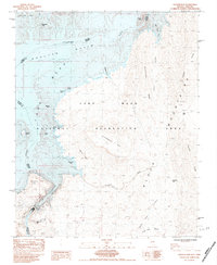
1983 Map of Hoover Dam
USGS Topo · Published 1984About this map
Hoover Dam stands as the primary focus of this early 1980s topographical study, anchoring the border between Clark County, Nevada and Mohave County, Arizona. The map details the complex geography created by the impoundment of the Colorado River, including the expansive waters of Boulder Basin and the winding reaches of Black Canyon. Away from the dam infrastructure, the landscape is defined by its geological features, from the high elevation of Fortification Hill and Sugarloaf Mtn to the colorful formations at the Paint Pots. Significant inlets and shoreline landmarks such as Shelter Cove, Beehive Island, and Sentinel Island show the interface of the Lake Mead National Recreation Area with the surrounding desert. Numerous prospects and 4wd trails crisscross the desert floor, hinting at the area's mineral exploration history and its role as a recreational destination for off-road travel.
Find a feature on this map
39 named features on this map. Tap any name to fly to it.
Don’t see what you’re looking for? This feature index may not catch every label — zoom into the map to look around manually.
Map Details
Editions of this 1983 Hoover Dam Map
This is the sole edition of this map. No revisions or reprints were ever made.
Other maps of this area

1886 · Camp Mohave
USGS Topo · 1:250,000

1886 · Saint Thomas
USGS Topo · 1:250,000

1892 · Camp Mohave
USGS Topo · 1:250,000

1893 · Saint Thomas
USGS Topo · 1:250,000

1926 · Nelson
USGS Topo · 1:96,000

1926 · Boulder Canyon
USGS Topo · 1:96,000

1942 · Camp Mohave
USGS Topo · 1:250,000

1947 · Kingman
USGS Topo · 1:250,000

1948 · Kingman
USGS Topo · 1:250,000

1952 · Henderson
USGS Topo · 1:62,500