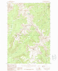
1987 Map of Iron Mountain
USGS Topo · Published 1987About this map
Iron Mountain serves as the focal point for this 1980s topographic study of the Montana backcountry. The landscape is defined by the high-elevation drainage systems of the Gallatin National Forest and the Absaroka-Beartooth Wilderness, where a network of steep canyons and alpine ridges dictates the movement of water and travelers alike. The map captures the intricate hydrology of the region, from the headwaters of Hellroaring Creek and its many branches to the South Fork Boulder River on the eastern edge. This era of mapping emphasizes preservation and natural boundaries, highlighting the Indefinite Boundary of wilderness zones. Local landmarks like Elk Lake and the Hummingbird Basin are presented alongside human markers such as the Corral Footbridge, offering a clear view of the primitive infrastructure used to navigate these mountain reaches before the turn of the century.
Find a feature on this map
23 named features on this map. Tap any name to fly to it.
Don’t see what you’re looking for? This feature index may not catch every label — zoom into the map to look around manually.
Map Details
Editions of this 1987 Iron Mountain Map
This is the sole edition of this map. No revisions or reprints were ever made.
Other maps of this area

1891 · Livingston
USGS Topo · 1:250,000

1893 · Livingston
USGS Topo · 1:250,000

1940 · Mt. Cowen
USGS Topo · 1:62,500

1940 · Mt Wallace
USGS Topo · 1:62,500

1941 · Mt Douglas
USGS Topo · 1:62,500

1942 · Cutoff Mtn
USGS Topo · 1:62,500

1943 · Mt Wallace
USGS Topo · 1:62,500

1943 · Mt Douglas
USGS Topo · 1:62,500

1943 · Mt Cowen
USGS Topo · 1:62,500

1944 · Cutoff Mtn
USGS Topo · 1:62,500