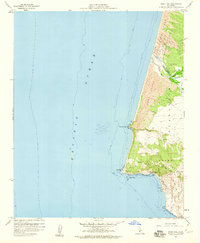
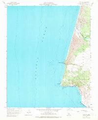
1958 Map of Point Sal
USGS Topo · Published 1960About this map
The Pacific Ocean coastline meets the dramatic Casmalia Ridge along this 1950s stretch of the Central Coast. The topography is defined by the shifting Sand Dunes north of the Santa Maria River, an area dominated by the Guadalupe Oil Field. This survey captures the region just as the southern portion was being integrated into the Vandenberg Air Force Base, showing the early road network including Vandenberg Road and Brown Road near the coastline.
Find a feature on this map
27 named features on this map. Tap any name to fly to it.
Don’t see what you’re looking for? This feature index may not catch every label — zoom into the map to look around manually.
Map Details
Editions of this 1958 Point Sal Map
3 editions found
Historical Maps of San Luis Obispo County Through Time
323 maps found

1941 McPherson Peak
Santa Barbara County, CA

1941 San Rafael Mtn
Santa Barbara County, CA

1942 Gaviota
Santa Barbara County, CA

1942 Little Pine Mountain
Santa Barbara County, CA

1942 Point Arguello
Santa Barbara County, CA

1942 Point Conception
Santa Barbara County, CA

1942 Point Sal
Santa Barbara County, CA

1942 San Rafael Mtn.
Santa Barbara County, CA

1942 Tepusquet Peak
Santa Barbara County, CA

1943 Big Pine Mountain
Santa Barbara County, CA

1943 Cuyama Ranch
Santa Barbara County, CA

1943 Fox Mountain
Santa Barbara County, CA

1943 Gaviota
Santa Barbara County, CA

1943 Hildreth Peak
Santa Barbara County, CA

1943 McPherson Peak
Santa Barbara County, CA

1943 Old Man Mountain
Santa Barbara County, CA

1943 San Miguel Island East
Santa Barbara County, CA

1943 San Miguel Island West
Santa Barbara County, CA

1943 San Rafael Mtn.
Santa Barbara County, CA

1943 Santa Cruz Island A
Santa Barbara County, CA

1943 Santa Cruz Island B
Santa Barbara County, CA

1943 Santa Cruz Island C
Santa Barbara County, CA

1943 Santa Cruz Island D
Santa Barbara County, CA

1943 Santa Rosa Island East
Santa Barbara County, CA

1943 Santa Rosa Island North
Santa Barbara County, CA

1943 Santa Rosa Island South
Santa Barbara County, CA

1943 Santa Rosa Island West
Santa Barbara County, CA

1943 Tepusquet Peak
Santa Barbara County, CA

1944 Big Pine Mtn
Santa Barbara County, CA

1944 Fox Mountain
Santa Barbara County, CA

1944 Hildreth Peak
Santa Barbara County, CA

1944 Little Pine Mountain
Santa Barbara County, CA

1944 Old Man Mountain
Santa Barbara County, CA

1944 Salisbury Potrero
Santa Barbara County, CA

1944 Strawberry Peak
Santa Barbara County, CA

1947 Careaga Canyon
Santa Barbara County, CA

1947 El Tranquillon
Santa Barbara County, CA

1947 Gaviota
Santa Barbara County, CA

1947 Los Coches Mtn
Santa Barbara County, CA

1947 Point Arguello
Santa Barbara County, CA

1947 Point Sal
Santa Barbara County, CA

1947 Santa Rosa Hills
Santa Barbara County, CA

1947 Surf
Santa Barbara County, CA

1948 El Tranquillon
Santa Barbara County, CA

1948 Lompoc Hills
Santa Barbara County, CA

1948 Point Arguello
Santa Barbara County, CA

1948 Point Sal
Santa Barbara County, CA

1950 San Miguel Island East
Santa Barbara County, CA

1950 San Miguel Island West
Santa Barbara County, CA

1951 Dos Pueblos Canyon
Santa Barbara County, CA

1953 Gaviota
Santa Barbara County, CA

1953 Point Conception
Santa Barbara County, CA

1953 Sacate
Santa Barbara County, CA

1953 Tajiguas
Santa Barbara County, CA

1958 Point Sal
Santa Barbara County, CA

1959 Figueroa Mtn
Santa Barbara County, CA

1959 Lake Cachuma
Santa Barbara County, CA

1959 Lompoc Hills
Santa Barbara County, CA

1959 Point Arguello
Santa Barbara County, CA

1959 Point Arguello
Santa Barbara County, CA

1959 Point Sal
Santa Barbara County, CA

1959 San Marcos Pass
Santa Barbara County, CA

1959 San Rafael Mtn
Santa Barbara County, CA

1959 San Rafael Mtn
Santa Barbara County, CA

1959 Santa Rosa Hills
Santa Barbara County, CA

1959 Surf
Santa Barbara County, CA

1959 Tranquillon Mtn
Santa Barbara County, CA

1959 Twitchell Dam
Santa Barbara County, CA

1959 Zaca Creek
Santa Barbara County, CA

1964 Bald Mountain
Santa Barbara County, CA

1964 Bates Canyon
Santa Barbara County, CA

1964 Big Pine Mtn
Santa Barbara County, CA

1964 Foxen Canyon
Santa Barbara County, CA

1964 Fox Mountain
Santa Barbara County, CA

1964 Gibraltar Dam
Santa Barbara County, CA

1964 Hildreth Peak
Santa Barbara County, CA

1964 Hurricane Deck
Santa Barbara County, CA

1964 Little Pine Mountain
Santa Barbara County, CA

1964 Madulce Peak
Santa Barbara County, CA

1964 Manzanita Mtn.
Santa Barbara County, CA

1964 Peak Mountain
Santa Barbara County, CA

1964 Salisbury Canyon
Santa Barbara County, CA

1964 Salisbury Potrero
Santa Barbara County, CA

1964 Tepusquet Canyon
Santa Barbara County, CA

1964 Zaca Lake
Santa Barbara County, CA

1965 Bald Mountain
Santa Barbara County, CA

1966 Gaviota
Santa Barbara County, CA

1967 Miranda Pine Mtn
Santa Barbara County, CA

1977 Bald Mtn
Santa Barbara County, CA

1977 Bates Canyon
Santa Barbara County, CA

1977 Big Pine Mtn
Santa Barbara County, CA

1980 Dos Pueblos Canyon
Santa Barbara County, CA

1981 Point Conception
Santa Barbara County, CA

1984 Laguna Harbor
Santa Barbara County, CA

1991 Old Man Mountain
Santa Barbara County, CA

1993 Santa Rosa Island
Santa Barbara County, CA

1995 Bald Mountain
Santa Barbara County, CA

1995 Bates Canyon
Santa Barbara County, CA

1995 Big Pine Mountain
Santa Barbara County, CA

1995 Dos Pueblos Canyon
Santa Barbara County, CA

1995 Figueroa Mountain
Santa Barbara County, CA

1995 Foxen Canyon
Santa Barbara County, CA

1995 Fox Mountain
Santa Barbara County, CA

1995 Gaviota
Santa Barbara County, CA

1995 Hildreth Peak
Santa Barbara County, CA

1995 Hurricane Deck
Santa Barbara County, CA

1995 Lake Cachuma
Santa Barbara County, CA

1995 Little Pine Mountain
Santa Barbara County, CA

1995 Madulce Peak
Santa Barbara County, CA

1995 Manzanita Mountain
Santa Barbara County, CA

1995 Miranda Pine Mountain
Santa Barbara County, CA

1995 Old Man Mountain
Santa Barbara County, CA

1995 Peak Mountain
Santa Barbara County, CA

1995 Salisbury Potrero
Santa Barbara County, CA

1995 San Marcos Pass
Santa Barbara County, CA

1995 San Rafael Mountain
Santa Barbara County, CA

1995 Tajiguas
Santa Barbara County, CA

1995 Tepusquet Canyon
Santa Barbara County, CA

1995 Zaca Lake
Santa Barbara County, CA

2012 Bald Mountain
Santa Barbara County, CA

2012 Bates Canyon
Santa Barbara County, CA

2012 Big Pine Mountain
Santa Barbara County, CA

2012 Casmalia OE W
Santa Barbara County, CA

2012 Dos Pueblos Canyon
Santa Barbara County, CA

2012 Figueroa Mountain
Santa Barbara County, CA

2012 Foxen Canyon
Santa Barbara County, CA

2012 Fox Mountain
Santa Barbara County, CA

2012 Gaviota
Santa Barbara County, CA

2012 Hildreth Peak
Santa Barbara County, CA

2012 Hurricane Deck
Santa Barbara County, CA

2012 Lake Cachuma
Santa Barbara County, CA

2012 Little Pine Mountain
Santa Barbara County, CA

2012 Lompoc Hills
Santa Barbara County, CA

2012 Madulce Peak
Santa Barbara County, CA

2012 Manzanita Mountain
Santa Barbara County, CA

2012 Miranda Pine Mountain
Santa Barbara County, CA

2012 Old Man Mountain
Santa Barbara County, CA

2012 Peak Mountain
Santa Barbara County, CA

2012 Point Arguello
Santa Barbara County, CA

2012 Point Conception
Santa Barbara County, CA

2012 Point Sal
Santa Barbara County, CA

2012 Sacate
Santa Barbara County, CA

2012 Salisbury Potrero
Santa Barbara County, CA

2012 San Marcos Pass
Santa Barbara County, CA

2012 San Miguel Island East
Santa Barbara County, CA

2012 San Miguel Island West
Santa Barbara County, CA

2012 San Rafael Mountain
Santa Barbara County, CA

2012 Santa Barbara Island OE N
Santa Barbara County, CA

2012 Santa Barbara Island
Santa Barbara County, CA

2012 Santa Cruz Island A
Santa Barbara County, CA

2012 Santa Cruz Island B OE S
Santa Barbara County, CA

2012 Santa Cruz Island B
Santa Barbara County, CA

2012 Santa Cruz Island C OE N
Santa Barbara County, CA

2012 Santa Cruz Island C
Santa Barbara County, CA

2012 Santa Cruz Island D OE S
Santa Barbara County, CA

2012 Santa Cruz Island D
Santa Barbara County, CA

2012 Santa Rosa Hills
Santa Barbara County, CA

2012 Santa Rosa Island East
Santa Barbara County, CA

2012 Santa Rosa Island North OE W
Santa Barbara County, CA

2012 Santa Rosa Island North
Santa Barbara County, CA

2012 Santa Rosa Island South
Santa Barbara County, CA

2012 Santa Rosa Island West
Santa Barbara County, CA

2012 Surf OE W
Santa Barbara County, CA

2012 Surf
Santa Barbara County, CA

2012 Tajiguas
Santa Barbara County, CA

2012 Tepusquet Canyon
Santa Barbara County, CA

2012 Tranquillon Mountain
Santa Barbara County, CA

2012 Twitchell Dam
Santa Barbara County, CA

2012 Zaca Creek
Santa Barbara County, CA

2012 Zaca Lake
Santa Barbara County, CA

2015 Bald Mountain
Santa Barbara County, CA

2015 Bates Canyon
Santa Barbara County, CA

2015 Big Pine Mountain
Santa Barbara County, CA

2015 Casmalia OE W
Santa Barbara County, CA

2015 Dos Pueblos Canyon
Santa Barbara County, CA

2015 Figueroa Mountain
Santa Barbara County, CA

2015 Foxen Canyon
Santa Barbara County, CA

2015 Fox Mountain
Santa Barbara County, CA

2015 Gaviota
Santa Barbara County, CA

2015 Hildreth Peak
Santa Barbara County, CA

2015 Hurricane Deck
Santa Barbara County, CA

2015 Lake Cachuma
Santa Barbara County, CA

2015 Little Pine Mountain
Santa Barbara County, CA

2015 Lompoc Hills
Santa Barbara County, CA

2015 Madulce Peak
Santa Barbara County, CA

2015 Manzanita Mountain
Santa Barbara County, CA

2015 Miranda Pine Mountain
Santa Barbara County, CA

2015 Old Man Mountain
Santa Barbara County, CA

2015 Peak Mountain
Santa Barbara County, CA

2015 Point Arguello
Santa Barbara County, CA

2015 Point Conception
Santa Barbara County, CA

2015 Point Sal
Santa Barbara County, CA

2015 Sacate
Santa Barbara County, CA

2015 Salisbury Potrero
Santa Barbara County, CA

2015 San Marcos Pass
Santa Barbara County, CA

2015 San Miguel Island East
Santa Barbara County, CA

2015 San Miguel Island West
Santa Barbara County, CA

2015 San Rafael Mountain
Santa Barbara County, CA

2015 Santa Barbara Island OE N
Santa Barbara County, CA

2015 Santa Barbara Island
Santa Barbara County, CA

2015 Santa Cruz Island A
Santa Barbara County, CA

2015 Santa Cruz Island B OE S
Santa Barbara County, CA

2015 Santa Cruz Island B
Santa Barbara County, CA

2015 Santa Cruz Island C OE N
Santa Barbara County, CA

2015 Santa Cruz Island C
Santa Barbara County, CA

2015 Santa Cruz Island D OE S
Santa Barbara County, CA

2015 Santa Cruz Island D
Santa Barbara County, CA

2015 Santa Rosa Hills
Santa Barbara County, CA

2015 Santa Rosa Island East
Santa Barbara County, CA

2015 Santa Rosa Island North OE W
Santa Barbara County, CA

2015 Santa Rosa Island North
Santa Barbara County, CA

2015 Santa Rosa Island South
Santa Barbara County, CA

2015 Santa Rosa Island West
Santa Barbara County, CA

2015 Surf OE W
Santa Barbara County, CA

2015 Surf
Santa Barbara County, CA

2015 Tajiguas
Santa Barbara County, CA

2015 Tepusquet Canyon
Santa Barbara County, CA

2015 Tranquillon Mountain
Santa Barbara County, CA

2015 Twitchell Dam
Santa Barbara County, CA

2015 Zaca Creek
Santa Barbara County, CA

2015 Zaca Lake
Santa Barbara County, CA

2018 Bald Mountain
Santa Barbara County, CA

2018 Bates Canyon
Santa Barbara County, CA

2018 Big Pine Mountain
Santa Barbara County, CA

2018 Casmalia OE W
Santa Barbara County, CA

2018 Dos Pueblos Canyon
Santa Barbara County, CA

2018 Figueroa Mountain
Santa Barbara County, CA

2018 Foxen Canyon
Santa Barbara County, CA

2018 Fox Mountain
Santa Barbara County, CA

2018 Gaviota
Santa Barbara County, CA

2018 Hildreth Peak
Santa Barbara County, CA

2018 Hurricane Deck
Santa Barbara County, CA

2018 Lake Cachuma
Santa Barbara County, CA

2018 Little Pine Mountain
Santa Barbara County, CA

2018 Lompoc Hills
Santa Barbara County, CA

2018 Madulce Peak
Santa Barbara County, CA

2018 Manzanita Mountain
Santa Barbara County, CA

2018 Miranda Pine Mountain
Santa Barbara County, CA

2018 Old Man Mountain
Santa Barbara County, CA

2018 Peak Mountain
Santa Barbara County, CA

2018 Point Arguello
Santa Barbara County, CA

2018 Point Conception
Santa Barbara County, CA

2018 Point Sal
Santa Barbara County, CA

2018 Sacate
Santa Barbara County, CA

2018 Salisbury Potrero
Santa Barbara County, CA

2018 San Marcos Pass
Santa Barbara County, CA

2018 San Miguel Island East
Santa Barbara County, CA

2018 San Miguel Island West
Santa Barbara County, CA

2018 San Rafael Mountain
Santa Barbara County, CA

2018 Santa Barbara Island OE N
Santa Barbara County, CA

2018 Santa Barbara Island
Santa Barbara County, CA

2018 Santa Cruz Island A
Santa Barbara County, CA

2018 Santa Cruz Island B OE S
Santa Barbara County, CA

2018 Santa Cruz Island B
Santa Barbara County, CA

2018 Santa Cruz Island C OE N
Santa Barbara County, CA

2018 Santa Cruz Island C
Santa Barbara County, CA

2018 Santa Cruz Island D OE S
Santa Barbara County, CA

2018 Santa Cruz Island D
Santa Barbara County, CA

2018 Santa Rosa Hills
Santa Barbara County, CA

2018 Santa Rosa Island East
Santa Barbara County, CA

2018 Santa Rosa Island North OE W
Santa Barbara County, CA

2018 Santa Rosa Island North
Santa Barbara County, CA

2018 Santa Rosa Island South
Santa Barbara County, CA

2018 Santa Rosa Island West
Santa Barbara County, CA

2018 Surf OE W
Santa Barbara County, CA

2018 Surf
Santa Barbara County, CA

2018 Tajiguas
Santa Barbara County, CA

2018 Tepusquet Canyon
Santa Barbara County, CA

2018 Tranquillon Mountain
Santa Barbara County, CA

2018 Twitchell Dam
Santa Barbara County, CA

2018 Zaca Creek
Santa Barbara County, CA

2018 Zaca Lake
Santa Barbara County, CA

2021 Bates Canyon
Santa Barbara County, CA

2021 Big Pine Mountain
Santa Barbara County, CA

2021 Casmalia OE W
Santa Barbara County, CA

2021 Foxen Canyon
Santa Barbara County, CA

2021 Fox Mountain
Santa Barbara County, CA

2021 Gaviota
Santa Barbara County, CA

2021 Hildreth Peak
Santa Barbara County, CA

2021 Hurricane Deck
Santa Barbara County, CA

2021 Lake Cachuma
Santa Barbara County, CA

2021 Little Pine Mountain
Santa Barbara County, CA

2021 Lompoc Hills
Santa Barbara County, CA

2021 Madulce Peak
Santa Barbara County, CA

2021 Manzanita Mountain
Santa Barbara County, CA

2021 Miranda Pine Mountain
Santa Barbara County, CA

2021 Peak Mountain
Santa Barbara County, CA

2021 Point Arguello
Santa Barbara County, CA

2021 Point Conception
Santa Barbara County, CA

2021 Point Sal
Santa Barbara County, CA

2021 Sacate
Santa Barbara County, CA

2021 Salisbury Potrero
Santa Barbara County, CA

2021 San Marcos Pass
Santa Barbara County, CA

2021 San Miguel Island East
Santa Barbara County, CA

2021 San Miguel Island West
Santa Barbara County, CA

2021 San Rafael Mountain
Santa Barbara County, CA

2021 Santa Barbara Island OE N
Santa Barbara County, CA

2021 Santa Barbara Island
Santa Barbara County, CA

2021 Santa Cruz Island A
Santa Barbara County, CA

2021 Santa Cruz Island B OE S
Santa Barbara County, CA

2021 Santa Cruz Island B
Santa Barbara County, CA

2021 Santa Cruz Island C OE N
Santa Barbara County, CA

2021 Santa Cruz Island C
Santa Barbara County, CA

2021 Santa Cruz Island D OE S
Santa Barbara County, CA

2021 Santa Cruz Island D
Santa Barbara County, CA

2021 Santa Rosa Hills
Santa Barbara County, CA

2021 Santa Rosa Island East
Santa Barbara County, CA

2021 Santa Rosa Island North OE W
Santa Barbara County, CA

2021 Santa Rosa Island North
Santa Barbara County, CA

2021 Santa Rosa Island South
Santa Barbara County, CA

2021 Santa Rosa Island West
Santa Barbara County, CA

2021 Surf OE W
Santa Barbara County, CA

2021 Surf
Santa Barbara County, CA

2021 Tajiguas
Santa Barbara County, CA

2021 Tepusquet Canyon
Santa Barbara County, CA

2021 Tranquillon Mountain
Santa Barbara County, CA

2021 Twitchell Dam
Santa Barbara County, CA

2021 Zaca Creek
Santa Barbara County, CA

2021 Zaca Lake
Santa Barbara County, CA

2022 Bald Mountain
Santa Barbara County, CA

2022 Dos Pueblos Canyon
Santa Barbara County, CA

2022 Figueroa Mountain
Santa Barbara County, CA

2022 Old Man Mountain
Santa Barbara County, CA