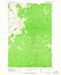
1964 Map of Granite Pass
USGS Topo · Published 1967About this map
The high Bitterroot Divide forms the backbone of this mid-1960s survey, marking the jagged boundary between Idaho and Montana. This rugged corridor is defined by the heavy timber of the Lolo National Forest and Clearwater National Forest, where infrastructure is limited to a network of high-altitude paths. Travel through the region relied on the State Line Trail and various other routes labeled as Pack Trail, emphasizing the area's isolation and its primary use for forestry and fire monitoring. A prominent landmark is the Lookout Tower at BM Hill, which provided a strategic vantage point over the drainage basins of Crooked Fork and Boulder Creek. Near the southern edge, Granite Pass serves as a critical transition point between the two states, while northern summits like Granite Peak and Pilot Knob dominate the skyline.
Find a feature on this map
22 named features on this map. Tap any name to fly to it.
Don’t see what you’re looking for? This feature index may not catch every label — zoom into the map to look around manually.
Map Details
Editions of this 1964 Granite Pass Map
2 editions found
Other maps of this area

1911 · Lolo
USGS Topo · 1:250,000

1913 · Lolo
USGS Topo · 1:250,000

1956 · Hamilton
USGS Topo · 1:250,000

1959 · Hamilton
USGS Topo · 1:250,000

1960 · Hamilton
USGS Topo · 1:250,000

1960 · Straight Peak
USGS Topo · 1:62,500

1964 · Hamilton
USGS Topo · 1:250,000

1964 · Lolo Hot Springs
USGS Topo · 1:24,000

1964 · Rocky Point
USGS Topo · 1:24,000
1964 · White Mountain
USGS Topo · 1:24,000