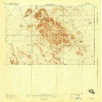
1918 Map of Dog Mountains
USGS Topo · Published 1943About this map
The Alamo Hueco Mountains and Dog Mountains dominate this arid borderlands landscape, surveyed during the First World War in cooperation with the War Department. Life in this corner of Hidalgo County revolved around scarce water sources, evidenced by the numerous named wells and springs scattered across the Playas Valley and the mountain canyons. The map documents a ranching economy defined by isolated outposts such as Pierce Ranch and Dog Spring Ranch, which relied on improvements like Campbells Well and White Mills Wells to sustain operations near the international boundary. Many of these features, including the Stone Cabin in Cottonwood Canyon, suggest a precarious frontier existence. The United States-Mexico Boundary Line defines the southern and eastern edges of the quadrangle, marking the remote geographic limit of New Mexico during this era of early twentieth-century topographic mapping.
Find a feature on this map
32 named features on this map. Tap any name to fly to it.
Don’t see what you’re looking for? This feature index may not catch every label — zoom into the map to look around manually.
Map Details
Editions of this 1918 Dog Mountains Map
3 editions found
Other maps of this area

1917 · Antelope Wells
USGS Topo · 1:62,500

1918 · Big Hatchet Peak
USGS Topo · 1:62,500

1918 · Dog Mountains
USGS Topo · 1:62,500

1918 · Walnut Wells
USGS Topo · 1:62,500

1919 · Antelope Wells
USGS Topo · 1:62,500

1923 · Walnut Wells
USGS Topo · 1:62,500

1955 · Douglas
USGS Topo · 1:250,000

1959 · Douglas
USGS Topo · 1:250,000

1961 · Douglas
USGS Topo · 1:250,000

1964 · Douglas
USGS Topo · 1:250,000