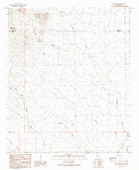
1989 Map of Greg Hills
USGS Topo · Published 1989About this map
Greg Hills dominate the northern landscape of this high desert terrain at the convergence of Sierra, Grant, and Luna Counties. This arid expanse is defined by a complex network of ephemeral drainage systems, including China Canyon Draw and Macho Creek, which illustrate the critical importance of water management in the American Southwest. The presence of Cotton Well, the China Tank, and several Check Dams speaks to the ranching infrastructure necessary to sustain life and livestock in this environment. Genealogists and historians interested in land use and boundary changes will find the intersection of the Sierra Co Grant Co Luna Co lines particularly noteworthy. The map also records natural features like Greg Spring and deep cuts such as Black Canyon, providing a clear view of the topography before modern developments altered these traditional cattle-grazing ranges.
Find a feature on this map
19 named features on this map. Tap any name to fly to it.
Don’t see what you’re looking for? This feature index may not catch every label — zoom into the map to look around manually.
Map Details
Editions of this 1989 Greg Hills Map
This is the sole edition of this map. No revisions or reprints were ever made.
Other maps of this area

1899 · Deming
USGS Topo · 1:125,000

1915 · Deming
USGS Topo · 1:125,000

1955 · Las Cruces
USGS Topo · 1:250,000

1958 · Las Cruces
USGS Topo · 1:250,000

1961 · Nutt
USGS Topo · 1:62,500

1962 · Lake Valley
USGS Topo · 1:62,500

1964 · Florida
USGS Topo · 1:24,000

1964 · Massacre Peak
USGS Topo · 1:24,000

1972 · Good Sight Peak
USGS Topo · 1:24,000

1982 · Hatch
USGS Topo · 1:100,000