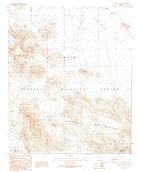
1990 Map of Cholla Tank
USGS Topo · Published 1990About this map
The Kofa National Wildlife Refuge dominates this desert landscape, where the sharp rise of the Kofa Mountains and the Little Horn Mountains meets the broad Ranegras Plain. This 1990 provisional survey records a territory defined by aridity and extraction, where vital water sources like Cholla Tank, Craven Well, and Red Rock Dam served as critical landmarks for travelers and prospectors alike. The presence of the Kofa Manganese Road and scattered Prospects near the La Paz Co Yuma Co boundary points to the region's mineral history. Navigation through these desert ranges relied on established routes through natural gaps like Red Rock Pass, connected by a network of unimproved tracks and a primitive Pack Trail. The drainage patterns of Alamo Wash and Red Raven Wash further illustrate the watershed dynamics of this protected Arizona wilderness.
Find a feature on this map
23 named features on this map. Tap any name to fly to it.
Don’t see what you’re looking for? This feature index may not catch every label — zoom into the map to look around manually.
Map Details
Editions of this 1990 Cholla Tank Map
This is the sole edition of this map. No revisions or reprints were ever made.
Other maps of this area

1942 · Vicksburg
USGS Topo · 1:250,000

1954 · Phoenix
USGS Topo · 1:250,000

1957 · Phoenix
USGS Topo · 1:250,000

1958 · Phoenix
USGS Topo · 1:250,000

1960 · Phoenix
USGS Topo · 1:250,000

1961 · Hope
USGS Topo · 1:62,500

1962 · Little Horn Mts
USGS Topo · 1:62,500

1962 · Kofa Butte
USGS Topo · 1:62,500

1962 · Vicksburg
USGS Topo · 1:62,500

1969 · Phoenix
USGS Topo · 1:250,000