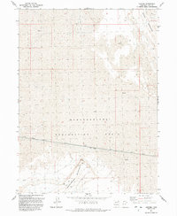
1991 Map of Groome
USGS Topo · Published 1991About this map
The isolated settlement of Groome sits along the southern edge of this map, defined by the industrial crossing of the Lucin Cutoff railroad. This line traverses a stark landscape dominated by the Newfoundland Evaporation Basin, where vast expanses of Mud meet the rising slopes of the Newfoundland Mountains and the Hogup Mountains. Resource extraction is evident in the foothills, with multiple Mines and Gravel Pits located near the peaks. The presence of a single Spring in the north and several survey points like BM 4216 emphasize the remote nature of this Great Salt Lake Desert region. The layout of the tracks and access roads designated as Private reflects the logistical challenges of maintaining a rail corridor through such an unforgiving, salt-caked environment in the late twentieth century.
Find a feature on this map
17 named features on this map. Tap any name to fly to it.
Don’t see what you’re looking for? This feature index may not catch every label — zoom into the map to look around manually.
Map Details
Editions of this 1991 Groome Map
This is the sole edition of this map. No revisions or reprints were ever made.
Other maps of this area

1954 · Brigham City
USGS Topo · 1:250,000

1958 · Brigham City
USGS Topo · 1:250,000

1962 · Brigham City
USGS Topo · 1:250,000

1983 · Desert Peak
USGS Topo · 1:24,000

1983 · Lemay
USGS Topo · 1:24,000

1983 · Round Mountain NW
USGS Topo · 1:24,000

1983 · Terrace Mountain East
USGS Topo · 1:24,000

1983 · Sheep Mountain
USGS Topo · 1:24,000

1983 · Groome
USGS Topo · 1:24,000
1983 · Meadow Spring
USGS Topo · 1:24,000