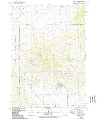
1988 Map of Grizzly Mtn
USGS Topo · Published 1988About this map
Grizzly Mountain dominates this landscape on the boundary of Jefferson and Crook counties. The map captures a transition from the Crooked River National Grassland in the west to the Ochoco National Forest in the east. Water management is a central theme of the southern terrain, where the Main Canal, Diversion Flume, and several smaller ditches support local agriculture near Ochoco Creek. Small rural centers like Grizzly and Grizzly 2 serve as localized hubs, while the presence of a Cem and family-named roads such as Grizzly Road and Puckett Road offer specific points of interest for genealogists. The summit of the mountain is marked by Radio Towers, indicating its importance for regional telecommunications at the end of the 1980s.
Find a feature on this map
34 named features on this map. Tap any name to fly to it.
Don’t see what you’re looking for? This feature index may not catch every label — zoom into the map to look around manually.
Map Details
Editions of this 1988 Grizzly Mtn Map
This is the sole edition of this map. No revisions or reprints were ever made.
Other maps of this area

1926 · Bend
USGS Topo · 1:125,000

1928 · Madras
USGS Topo · 1:125,000

1929 · Bend
USGS Topo · 1:125,000

1931 · Madras
USGS Topo · 1:125,000

1955 · Bend
USGS Topo · 1:250,000

1957 · Bend
USGS Topo · 1:250,000

1958 · Bend
USGS Topo · 1:250,000

1962 · Oneil
USGS Topo · 1:24,000

1962 · Huston Lake
USGS Topo · 1:24,000

1962 · Prineville
USGS Topo · 1:24,000