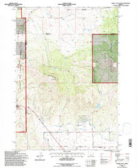
1992 Map of Grizzly Mtn
USGS Topo · Published 1997About this map
Grizzly Mountain dominates this portion of Central Oregon, serving as a high-altitude anchor between the high desert and forested highlands. This 1990s revision by the U.S. Forest Service documents a complex landscape where the Ochoco National Forest meets the Crooked River National Grassland. The map reveals a sophisticated water management system critical to this arid region, featuring the Ochoco Main Canal, several sections of flume, and a Diversion Flume. Infrastructure for communication and utilities is prominent, with the Grizzly Towers and the Grizzly 2-B Radio Tower marking the peaks, while a Pipeline and Sewage Disposal Pond indicate modern development. Local history is preserved in labels like the small Cem and family-named routes such as Merritt Road and Mc Cabe Rd, which provide a look at the land use and property divisions in Crook County during the late twentieth century.
Find a feature on this map
29 named features on this map. Tap any name to fly to it.
Don’t see what you’re looking for? This feature index may not catch every label — zoom into the map to look around manually.
Map Details
Editions of this 1992 Grizzly Mtn Map
This is the sole edition of this map. No revisions or reprints were ever made.
Other maps of this area

1926 · Bend
USGS Topo · 1:125,000

1928 · Madras
USGS Topo · 1:125,000

1929 · Bend
USGS Topo · 1:125,000

1931 · Madras
USGS Topo · 1:125,000

1955 · Bend
USGS Topo · 1:250,000

1957 · Bend
USGS Topo · 1:250,000

1958 · Bend
USGS Topo · 1:250,000

1962 · Oneil
USGS Topo · 1:24,000

1962 · Huston Lake
USGS Topo · 1:24,000

1962 · Prineville
USGS Topo · 1:24,000