
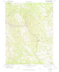
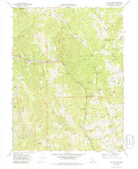
1969 Map of Tan Oak Park
USGS Topo · Published 1994About this map
Rattlesnake Creek carves a deep path through the Mendocino highlands, anchoring a landscape defined by isolated ranches and winding mountain roads. This 1969 survey, updated in the early 1990s, documents a transition between early homesteading footprints and mid-century recreation. While Tan Oak Park and the Empire Roadside Rest suggest the influence of modern travelers, the interior remains dominated by family-named landmarks like Elder Place, Bald Mtn Ranch, and Redwine Ranch.
Find a feature on this map
47 named features on this map. Tap any name to fly to it.
Don’t see what you’re looking for? This feature index may not catch every label — zoom into the map to look around manually.
Map Details
Editions of this 1969 Tan Oak Park Map
3 editions found
Historical Maps of Twin Rocks Through Time
331 maps found

1920 Cummings
Mendocino County, CA

1920 Glenblair
Mendocino County, CA

1921 Branscomb
Mendocino County, CA

1921 Cape Vizcaino
Mendocino County, CA

1929 Eden Valley
Mendocino County, CA

1943 Glenblair
Mendocino County, CA

1943 Navarro
Mendocino County, CA

1943 Ornbaun
Mendocino County, CA

1943 Pomo
Mendocino County, CA

1944 Ornbaun
Mendocino County, CA

1944 Saddle Point
Mendocino County, CA

1950 Cape Vizcaino
Mendocino County, CA

1950 Piercy
Mendocino County, CA

1951 Branscomb
Mendocino County, CA

1951 Cape Vizcaino
Mendocino County, CA

1952 Eden Valley
Mendocino County, CA

1952 Spyrock
Mendocino County, CA

1958 Cow Mountain
Mendocino County, CA

1958 Elledge Peak
Mendocino County, CA

1958 Purdys Gardens
Mendocino County, CA

1960 Elk
Mendocino County, CA

1960 Gualala
Mendocino County, CA

1960 Mallo Pass Creek
Mendocino County, CA

1960 Ornbaun Valley
Mendocino County, CA

1960 Saunders Reef
Mendocino County, CA

1961 Navarro
Mendocino County, CA

1966 Brushy Mtn
Mendocino County, CA

1966 Dutchmans Knoll
Mendocino County, CA

1966 Inglenook
Mendocino County, CA

1966 Leech Lake Mtn.
Mendocino County, CA

1966 Lincoln Ridge
Mendocino County, CA

1966 Longvale
Mendocino County, CA

1966 Sanhedrin Mtn
Mendocino County, CA

1966 Westport
Mendocino County, CA

1966 Willis Ridge
Mendocino County, CA

1967 Bluenose Ridge
Mendocino County, CA

1967 Buck Rock
Mendocino County, CA

1967 Cahto Peak
Mendocino County, CA

1967 Covelo East
Mendocino County, CA

1967 Covelo West
Mendocino County, CA

1967 Dos Rios
Mendocino County, CA

1967 Hull Mountain
Mendocino County, CA

1967 Iron Peak
Mendocino County, CA

1967 Jamison Ridge
Mendocino County, CA

1967 Mendocino Pass
Mendocino County, CA

1967 Mina
Mendocino County, CA

1967 Newhouse Ridge
Mendocino County, CA

1967 Plaskett Ridge
Mendocino County, CA

1967 Sherwood Peak
Mendocino County, CA

1967 Thatcher Ridge
Mendocino County, CA

1967 Updegraff Ridge
Mendocino County, CA

1969 Bear Harbor
Mendocino County, CA

1969 Bell Springs
Mendocino County, CA

1969 Mistake Point
Mendocino County, CA

1969 Noble Butte
Mendocino County, CA

1969 Piercy
Mendocino County, CA
1969 Tan Oak Park
Mendocino County, CA

1970 Hales Grove
Mendocino County, CA

1977 Gualala
Mendocino County, CA

1991 Bailey Ridge
Mendocino County, CA

1991 Big Foot Mountain
Mendocino County, CA

1991 Burbeck
Mendocino County, CA

1991 Cold Spring
Mendocino County, CA

1991 Eureka Hill
Mendocino County, CA

1991 Foster Mountain
Mendocino County, CA

1991 Greenough Ridge
Mendocino County, CA

1991 Gube Mountain
Mendocino County, CA

1991 Laughlin Range
Mendocino County, CA

1991 Mathison Peak
Mendocino County, CA

1991 Mc Guire Ridge
Mendocino County, CA

1991 Navarro
Mendocino County, CA

1991 Northspur
Mendocino County, CA

1991 Noyo Hill
Mendocino County, CA

1991 Ornbaun Valley
Mendocino County, CA

1991 Orrs Springs
Mendocino County, CA

1991 Van Arsdale Reservoir
Mendocino County, CA

1991 Yorkville
Mendocino County, CA

1991 Zeni Ridge
Mendocino County, CA

1994 Dutchmans Knoll
Mendocino County, CA

1995 Bluenose Ridge
Mendocino County, CA

1995 Buck Rock
Mendocino County, CA

1995 Leech Lake Mountain
Mendocino County, CA

1995 Newhouse Ridge
Mendocino County, CA

1995 Thatcher Ridge
Mendocino County, CA

1996 Brushy Mountain
Mendocino County, CA

1996 Foster Mountain
Mendocino County, CA

1996 Hull Mountain
Mendocino County, CA

1996 Mendocino Pass
Mendocino County, CA

1996 Plaskett Ridge
Mendocino County, CA

1996 Sanhedrin Mountain
Mendocino County, CA

1996 Van Arsdale Reservoir
Mendocino County, CA

1997 Bear Harbor
Mendocino County, CA

1998 Gualala
Mendocino County, CA

2012 Bailey Ridge
Mendocino County, CA

2012 Bear Harbor
Mendocino County, CA

2012 Bear Harbor OE W
Mendocino County, CA

2012 Bell Springs
Mendocino County, CA

2012 Big Foot Mountain
Mendocino County, CA

2012 Bluenose Ridge
Mendocino County, CA

2012 Brushy Mountain
Mendocino County, CA

2012 Buck Rock
Mendocino County, CA

2012 Burbeck
Mendocino County, CA

2012 Cahto Peak
Mendocino County, CA

2012 Cold Spring
Mendocino County, CA

2012 Covelo East
Mendocino County, CA

2012 Covelo West
Mendocino County, CA

2012 Cow Mountain
Mendocino County, CA

2012 Dos Rios
Mendocino County, CA

2012 Dutchmans Knoll
Mendocino County, CA

2012 Elk
Mendocino County, CA

2012 Elledge Peak
Mendocino County, CA

2012 Eureka Hill
Mendocino County, CA

2012 Foster Mountain
Mendocino County, CA

2012 Greenough Ridge
Mendocino County, CA

2012 Gualala
Mendocino County, CA

2012 Gube Mountain
Mendocino County, CA

2012 Hales Grove
Mendocino County, CA

2012 Hull Mountain
Mendocino County, CA

2012 Inglenook
Mendocino County, CA

2012 Iron Peak
Mendocino County, CA

2012 Jamison Ridge
Mendocino County, CA

2012 Laughlin Range
Mendocino County, CA

2012 Leech Lake Mountain
Mendocino County, CA

2012 Lincoln Ridge
Mendocino County, CA

2012 Longvale
Mendocino County, CA

2012 Mallo Pass Creek
Mendocino County, CA

2012 Mathison Peak
Mendocino County, CA

2012 McGuire Ridge
Mendocino County, CA

2012 Mendocino Pass
Mendocino County, CA

2012 Mina
Mendocino County, CA

2012 Mistake Point
Mendocino County, CA

2012 Navarro
Mendocino County, CA

2012 Newhouse Ridge
Mendocino County, CA

2012 Noble Butte
Mendocino County, CA

2012 Northspur
Mendocino County, CA

2012 Noyo Hill
Mendocino County, CA

2012 Ornbaun Valley
Mendocino County, CA

2012 Orrs Springs
Mendocino County, CA

2012 Piercy
Mendocino County, CA

2012 Plaskett Ridge
Mendocino County, CA

2012 Purdys Gardens
Mendocino County, CA

2012 Sanhedrin Mountain
Mendocino County, CA

2012 Saunders Reef
Mendocino County, CA

2012 Sherwood Peak
Mendocino County, CA

2012 Tan Oak Park
Mendocino County, CA

2012 Thatcher Ridge
Mendocino County, CA

2012 Updegraff Ridge
Mendocino County, CA

2012 Van Arsdale Reservoir
Mendocino County, CA

2012 Westport
Mendocino County, CA

2012 Willis Ridge
Mendocino County, CA

2012 Yorkville
Mendocino County, CA

2012 Zeni Ridge
Mendocino County, CA

2015 Bailey Ridge
Mendocino County, CA

2015 Bear Harbor
Mendocino County, CA

2015 Bear Harbor OE W
Mendocino County, CA

2015 Bell Springs
Mendocino County, CA

2015 Big Foot Mountain
Mendocino County, CA

2015 Bluenose Ridge
Mendocino County, CA

2015 Brushy Mountain
Mendocino County, CA

2015 Buck Rock
Mendocino County, CA

2015 Burbeck
Mendocino County, CA

2015 Cahto Peak
Mendocino County, CA

2015 Cold Spring
Mendocino County, CA

2015 Covelo East
Mendocino County, CA

2015 Covelo West
Mendocino County, CA

2015 Cow Mountain
Mendocino County, CA

2015 Dos Rios
Mendocino County, CA

2015 Dutchmans Knoll
Mendocino County, CA

2015 Elk
Mendocino County, CA

2015 Elledge Peak
Mendocino County, CA

2015 Eureka Hill
Mendocino County, CA

2015 Foster Mountain
Mendocino County, CA

2015 Greenough Ridge
Mendocino County, CA

2015 Gualala
Mendocino County, CA

2015 Gube Mountain
Mendocino County, CA

2015 Hales Grove
Mendocino County, CA

2015 Hull Mountain
Mendocino County, CA

2015 Inglenook
Mendocino County, CA

2015 Iron Peak
Mendocino County, CA

2015 Jamison Ridge
Mendocino County, CA

2015 Laughlin Range
Mendocino County, CA

2015 Leech Lake Mountain
Mendocino County, CA

2015 Lincoln Ridge
Mendocino County, CA

2015 Longvale
Mendocino County, CA

2015 Mallo Pass Creek
Mendocino County, CA

2015 Mathison Peak
Mendocino County, CA

2015 McGuire Ridge
Mendocino County, CA

2015 Mendocino Pass
Mendocino County, CA

2015 Mina
Mendocino County, CA

2015 Mistake Point
Mendocino County, CA

2015 Navarro
Mendocino County, CA

2015 Newhouse Ridge
Mendocino County, CA

2015 Noble Butte
Mendocino County, CA

2015 Northspur
Mendocino County, CA

2015 Noyo Hill
Mendocino County, CA

2015 Ornbaun Valley
Mendocino County, CA

2015 Orrs Springs
Mendocino County, CA

2015 Piercy
Mendocino County, CA

2015 Plaskett Ridge
Mendocino County, CA

2015 Purdys Gardens
Mendocino County, CA

2015 Sanhedrin Mountain
Mendocino County, CA

2015 Saunders Reef
Mendocino County, CA

2015 Sherwood Peak
Mendocino County, CA

2015 Tan Oak Park
Mendocino County, CA

2015 Thatcher Ridge
Mendocino County, CA

2015 Updegraff Ridge
Mendocino County, CA

2015 Van Arsdale Reservoir
Mendocino County, CA

2015 Westport
Mendocino County, CA

2015 Willis Ridge
Mendocino County, CA

2015 Yorkville
Mendocino County, CA

2015 Zeni Ridge
Mendocino County, CA

2018 Bailey Ridge
Mendocino County, CA

2018 Bear Harbor
Mendocino County, CA

2018 Bear Harbor OE W
Mendocino County, CA

2018 Bell Springs
Mendocino County, CA

2018 Big Foot Mountain
Mendocino County, CA

2018 Bluenose Ridge
Mendocino County, CA

2018 Brushy Mountain
Mendocino County, CA

2018 Buck Rock
Mendocino County, CA

2018 Burbeck
Mendocino County, CA

2018 Cahto Peak
Mendocino County, CA

2018 Cold Spring
Mendocino County, CA

2018 Covelo East
Mendocino County, CA

2018 Covelo West
Mendocino County, CA

2018 Cow Mountain
Mendocino County, CA

2018 Dos Rios
Mendocino County, CA

2018 Dutchmans Knoll
Mendocino County, CA

2018 Elk
Mendocino County, CA

2018 Elledge Peak
Mendocino County, CA

2018 Eureka Hill
Mendocino County, CA

2018 Foster Mountain
Mendocino County, CA

2018 Greenough Ridge
Mendocino County, CA

2018 Gualala
Mendocino County, CA

2018 Gube Mountain
Mendocino County, CA

2018 Hales Grove
Mendocino County, CA

2018 Hull Mountain
Mendocino County, CA

2018 Inglenook
Mendocino County, CA

2018 Iron Peak
Mendocino County, CA

2018 Jamison Ridge
Mendocino County, CA

2018 Laughlin Range
Mendocino County, CA

2018 Leech Lake Mountain
Mendocino County, CA

2018 Lincoln Ridge
Mendocino County, CA

2018 Longvale
Mendocino County, CA

2018 Mallo Pass Creek
Mendocino County, CA

2018 Mathison Peak
Mendocino County, CA

2018 McGuire Ridge
Mendocino County, CA

2018 Mendocino Pass
Mendocino County, CA

2018 Mina
Mendocino County, CA

2018 Mistake Point
Mendocino County, CA

2018 Navarro
Mendocino County, CA

2018 Newhouse Ridge
Mendocino County, CA

2018 Noble Butte
Mendocino County, CA

2018 Northspur
Mendocino County, CA

2018 Noyo Hill
Mendocino County, CA

2018 Ornbaun Valley
Mendocino County, CA

2018 Orrs Springs
Mendocino County, CA

2018 Piercy
Mendocino County, CA

2018 Plaskett Ridge
Mendocino County, CA

2018 Purdys Gardens
Mendocino County, CA

2018 Sanhedrin Mountain
Mendocino County, CA

2018 Saunders Reef
Mendocino County, CA

2018 Sherwood Peak
Mendocino County, CA

2018 Tan Oak Park
Mendocino County, CA

2018 Thatcher Ridge
Mendocino County, CA

2018 Updegraff Ridge
Mendocino County, CA

2018 Van Arsdale Reservoir
Mendocino County, CA

2018 Westport
Mendocino County, CA

2018 Willis Ridge
Mendocino County, CA

2018 Yorkville
Mendocino County, CA

2018 Zeni Ridge
Mendocino County, CA

2021 Bailey Ridge
Mendocino County, CA

2021 Bear Harbor
Mendocino County, CA

2021 Bear Harbor OE W
Mendocino County, CA

2021 Bell Springs
Mendocino County, CA

2021 Big Foot Mountain
Mendocino County, CA

2021 Bluenose Ridge
Mendocino County, CA

2021 Brushy Mountain
Mendocino County, CA

2021 Buck Rock
Mendocino County, CA

2021 Burbeck
Mendocino County, CA

2021 Cahto Peak
Mendocino County, CA

2021 Cold Spring
Mendocino County, CA

2021 Covelo East
Mendocino County, CA

2021 Covelo West
Mendocino County, CA

2021 Cow Mountain
Mendocino County, CA

2021 Dos Rios
Mendocino County, CA

2021 Dutchmans Knoll
Mendocino County, CA

2021 Elk
Mendocino County, CA

2021 Elledge Peak
Mendocino County, CA

2021 Eureka Hill
Mendocino County, CA

2021 Foster Mountain
Mendocino County, CA

2021 Greenough Ridge
Mendocino County, CA

2021 Gualala
Mendocino County, CA

2021 Gube Mountain
Mendocino County, CA

2021 Hull Mountain
Mendocino County, CA

2021 Inglenook
Mendocino County, CA

2021 Iron Peak
Mendocino County, CA

2021 Jamison Ridge
Mendocino County, CA

2021 Laughlin Range
Mendocino County, CA

2021 Leech Lake Mountain
Mendocino County, CA

2021 Lincoln Ridge
Mendocino County, CA

2021 Longvale
Mendocino County, CA

2021 Mallo Pass Creek
Mendocino County, CA

2021 Mathison Peak
Mendocino County, CA

2021 McGuire Ridge
Mendocino County, CA

2021 Mendocino Pass
Mendocino County, CA

2021 Mina
Mendocino County, CA

2021 Navarro
Mendocino County, CA

2021 Newhouse Ridge
Mendocino County, CA

2021 Noble Butte
Mendocino County, CA

2021 Northspur
Mendocino County, CA

2021 Noyo Hill
Mendocino County, CA

2021 Ornbaun Valley
Mendocino County, CA

2021 Orrs Springs
Mendocino County, CA

2021 Piercy
Mendocino County, CA

2021 Plaskett Ridge
Mendocino County, CA

2021 Purdys Gardens
Mendocino County, CA

2021 Sanhedrin Mountain
Mendocino County, CA

2021 Saunders Reef
Mendocino County, CA

2021 Sherwood Peak
Mendocino County, CA

2021 Tan Oak Park
Mendocino County, CA

2021 Thatcher Ridge
Mendocino County, CA

2021 Updegraff Ridge
Mendocino County, CA

2021 Van Arsdale Reservoir
Mendocino County, CA

2021 Westport
Mendocino County, CA

2021 Willis Ridge
Mendocino County, CA

2021 Yorkville
Mendocino County, CA

2021 Zeni Ridge
Mendocino County, CA

2022 Hales Grove
Mendocino County, CA

2022 Mistake Point
Mendocino County, CA

2023 Bailey Ridge
Mendocino County, CA

2023 McGuire Ridge
Mendocino County, CA