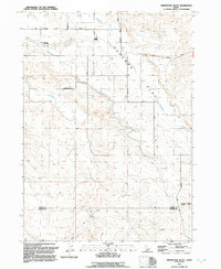
1992 Map of Grindstone Butte
USGS Topo · Published 1992About this map
Deadman Flat dominates this high-desert landscape in southern Idaho, where the topography is defined by the significant rise of Grindstone Butte. This 1992 revision, based on photography from the 1940s and late 1980s, details the sparse but essential infrastructure of the high plateau. The map marks the boundary between Elmore and Owyhee counties, a remote area where water sources like Dove Spring, Deadman Creek, and Sailor Creek are critical features. The transition from range to rugged slopes is evidenced by the namesake Solosabal-Sailor settlement area and the network of unpaved routes including West Grindstone Road and Flint Mesa Road. These tracks provide the primary access through the drainage systems and to small-scale industrial sites like the local Gravel Pit.
Find a feature on this map
13 named features on this map. Tap any name to fly to it.
Don’t see what you’re looking for? This feature index may not catch every label — zoom into the map to look around manually.
Map Details
Editions of this 1992 Grindstone Butte Map
This is the sole edition of this map. No revisions or reprints were ever made.
Other maps of this area

1947 · Hammett
USGS Topo · 1:24,000

1947 · Glenns Ferry
USGS Topo · 1:24,000

1947 · Pasadena Valley
USGS Topo · 1:24,000

1948 · Pasadena Valley
USGS Topo · 1:24,000

1948 · Hammett
USGS Topo · 1:24,000

1948 · Glenns Ferry
USGS Topo · 1:24,000

1948 · Twentymile Butte
USGS Topo · 1:24,000

1948 · Glenns Ferry
USGS Topo · 1:62,500

1948 · Grindstone Butte
USGS Topo · 1:24,000
1949 · Pot Hole Canyon
USGS Topo · 1:24,000