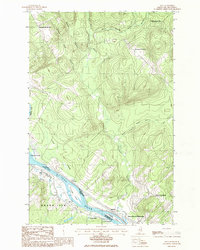
1986 Map of Lille
USGS Topo · Published 1986About this map
The St John River serves as the international boundary between Grand Isle, Maine, and New Brunswick, Canada, in this mid-1980s topograhic survey. The settlement of Lille sits along the American bank, while the Canadian side features the town of Sainte-Anne-de-Madawaska and the small hamlet of Notre Dame. Large river features like La Grande Island and Quisibis Island dominate the waterway, highlighting the historical importance of the river for both transport and geography. In the northern reaches of the map, the terrain rises into named heights including Montagne-des-Therrien, Montagne-de-la-Croix, and Montagne-des-Roy. Tributaries such as the Rivière Quisibis and Ruisseau Pierre la Melasse drain the uplands, cutting through the river valley. The map documents the persistent French-Acadian cultural influence in the region, seen in local place names like Rang-des-Deschêne and Plaine Jérôme.
Find a feature on this map
26 named features on this map. Tap any name to fly to it.
Don’t see what you’re looking for? This feature index may not catch every label — zoom into the map to look around manually.
Map Details
Editions of this 1986 Lille Map
This is the sole edition of this map. No revisions or reprints were ever made.
Other maps of this area

1921 · Van Buren
USGS Topo · 1:250,000

1927 · Stockholm
USGS Topo · 1:48,000

1931 · Van Buren
USGS Topo · 1:48,000

1931 · Stockholm
USGS Topo · 1:62,500

1934 · Van Buren
USGS Topo · 1:62,500

1938 · Grand Isle
USGS Topo · 1:62,500

1940 · Grand Isle
USGS Topo · 1:62,500

1951 · Van Buren
USGS Topo · 1:62,500

1953 · Stockholm
USGS Topo · 1:62,500

1962 · Edmundston
USGS Topo · 1:250,000