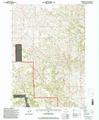
1995 Map of Hodsdon Flats
USGS Topo · Published 1998About this map
Custer National Forest lands dominate this mid-1990s landscape in Powder River County, Montana. The topography is defined by the high, flat expanses of Hodsdon Flats and the prominent elevations of Gardner Butte and Bailey Hill. Water management in this arid environment is evident through several small impoundments such as Turtle Reservoir and Calloway Reservoir, along with numerous named seeps like Deadman Spring and Fence Corner Spring. The drainage patterns are intricate, with the North Fork South Fork Cache Creek and several draws, including Sawmill Draw and Coal Draw, carving through the plateau. A notable administrative boundary, the 1st Standard Parallel South, bisects the northern half of the area, marking a significant surveying line in the state's public land system. This map captures a remote section of the American West focused on ranching and national forest stewardship.
Find a feature on this map
26 named features on this map. Tap any name to fly to it.
Don’t see what you’re looking for? This feature index may not catch every label — zoom into the map to look around manually.
Map Details
Editions of this 1995 Hodsdon Flats Map
This is the sole edition of this map. No revisions or reprints were ever made.
Other maps of this area

1954 · Ekalaka
USGS Topo · 1:250,000

1956 · Ekalaka
USGS Topo · 1:250,000

1958 · Ekalaka
USGS Topo · 1:250,000

1965 · Ekalaka
USGS Topo · 1:250,000

1966 · Sonnette
USGS Topo · 1:24,000

1966 · Phillips Butte
USGS Topo · 1:24,000

1966 · Hodsdon Flats
USGS Topo · 1:24,000

1966 · Threemile Buttes
USGS Topo · 1:24,000

1970 · Bloom Creek
USGS Topo · 1:24,000

1970 · Huckins School
USGS Topo · 1:24,000