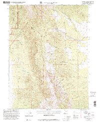
1998 Map of Johnson Pass
USGS Topo · Published 2001About this map
The high ridges of the Stansbury Mountains and Onaqui Mountains converge in this high-altitude landscape of Tooele County. The terrain is defined by its dramatic relief, where Johnson Pass serves as the primary corridor through the peaks, and Davids Gate Narrows marks a significant geological bottleneck. Evidence of human habitation is concentrated in the small settlement of Terra and a nearby Mobile Home Park, while much of the land is preserved within the Wasatch National Forest. The map is particularly useful for identifying ephemeral and permanent water sources in this arid region, including Slater Spring, Stockton Spring, and the prominent drainage of Glover Creek. Mining history is represented by scattered Prospect and Mine notations along the canyon walls, specifically near Big Cave Canyon and Settlement Canyon.
Find a feature on this map
37 named features on this map. Tap any name to fly to it.
Don’t see what you’re looking for? This feature index may not catch every label — zoom into the map to look around manually.
Map Details
Editions of this 1998 Johnson Pass Map
This is the sole edition of this map. No revisions or reprints were ever made.
Other maps of this area

1885 · Tooele Valley
USGS Topo · 1:250,000

1918 · Stockton
USGS Topo · 1:62,500

1953 · Tooele
USGS Topo · 1:250,000

1955 · Davis Knolls
USGS Topo · 1:24,000

1955 · Deseret Peak
USGS Topo · 1:62,500

1955 · Stockton
USGS Topo · 1:62,500

1955 · Tooele
USGS Topo · 1:250,000
1971 · Faust
USGS Topo · 1:24,000

1971 · Onaqui Mts South
USGS Topo · 1:24,000

1979 · Rush Valley
USGS Topo · 1:100,000