
1971 Map of Canon Olguin
USGS Topo · Published 1975About this map
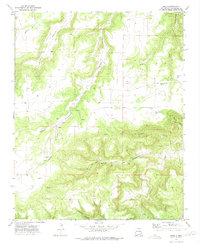
Trementina Creek and its complex network of drainage systems define this section of San Miguel County, as documented in the early 1970s. The landscape is characterized by prominent high-altitude plateaus, including Mesa Huerfana and Mesa Huerfanita, which rise above a series of deeply etched canyons such as Cañon Olguin and Cañon Largo. Human presence in this environment is sparse, indicated primarily by a network of Jeep Trails and Pack Trails that navigate the varied elevations. Notable landforms like Banco Quemado and the presence of a single marked Grave south of Cañon Encierto suggest a history of seasonal ranching or passage through this territory. The convergence of Arroyo Huerfana and Arroyo Hondo in the southern reaches highlights the drainage patterns essential to the local topography.
Find a feature on this map
25 named features on this map. Tap any name to fly to it.
Don’t see what you’re looking for? This feature index may not catch every label — zoom into the map to look around manually.
Map Details
Editions of this 1971 Canon Olguin Map
This is the sole edition of this map. No revisions or reprints were ever made.
Other maps of this area

1892 · Watrous
USGS Topo · 1:125,000

1892 · Corazon
USGS Topo · 1:125,000

1894 · Corazon
USGS Topo · 1:125,000

1894 · Watrous
USGS Topo · 1:125,000

1954 · Santa Fe
USGS Topo · 1:250,000

1958 · Santa Fe
USGS Topo · 1:250,000

1971 · Trujillo
USGS Topo · 1:24,000

1972 · Variadero
USGS Topo · 1:24,000
1972 · Maes
USGS Topo · 1:24,000
1972 · Llonidas Lake
USGS Topo · 1:24,000