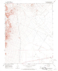
1968 Map of Crow Springs
USGS Topo · Published 1970About this map
The Monte Cristo Range dominates the western half of this Nevada landscape, where the high peaks of the Great Basin descend into the wide expanses of the Big Smoky Valley. This 1968 survey documents a remote mining and exploration environment, centered on the reliable water source at Crow Springs. The terrain is marked by the scars of industrial mineral exploration, from high-altitude Quarries and a Quarry in the north to scattered Prospects and a Drill Hole further east. A network of Jeep Trails provides the primary access through the steep draws beneath Doyle Peak. Near the valley floor, several benchmark locations like BM 4772 and a Gravel Pit indicate the logistical points for road maintenance and resource extraction during this mid-century period.
Find a feature on this map
18 named features on this map. Tap any name to fly to it.
Don’t see what you’re looking for? This feature index may not catch every label — zoom into the map to look around manually.
Map Details
Editions of this 1968 Crow Springs Map
This is the sole edition of this map. No revisions or reprints were ever made.
Other maps of this area

1907 · Tonopah
USGS Topo · 1:250,000

1908 · Tonopah
USGS Topo · 1:250,000

1956 · Tonopah
USGS Topo · 1:250,000

1959 · Tonopah
USGS Topo · 1:250,000

1961 · Lone Mtn
USGS Topo · 1:62,500

1962 · Tonopah
USGS Topo · 1:250,000

1964 · San Antonio Ranch
USGS Topo · 1:62,500
1968 · Gilbert SE
USGS Topo · 1:24,000
1968 · Gilbert
USGS Topo · 1:24,000
1968 · Devils Gate
USGS Topo · 1:24,000