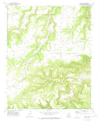
1972 Map of Maes
USGS Topo · Published 1975About this map
Maes sits within a landscape defined by deep drainages and cattle-ranching territory in San Miguel County. The topography is dominated by dramatic relief, specifically where Cañon Encincoso and Pajarita converge. This area reflects a traditional New Mexican settlement pattern, with small family holdings and educational outposts such as Maestas School serving a scattered population. The map reveals the vital importance of water in this semi-arid environment, with numerous unnamed Spring locations and Juan Torres Lake providing essential resources. Local heritage is preserved in small burial sites like the Juan Torres Cem and several other marked Cem and Grave locations, which offer valuable data for genealogists tracing families in the region. The network of Jeep Trails and primitive roads suggests a reliance on high-clearance transport to navigate between the high mesas and the canyon floors of Cañon Largo and Middle Canyon.
Find a feature on this map
23 named features on this map. Tap any name to fly to it.
Don’t see what you’re looking for? This feature index may not catch every label — zoom into the map to look around manually.
Map Details
Editions of this 1972 Maes Map
This is the sole edition of this map. No revisions or reprints were ever made.
Other maps of this area

1892 · Watrous
USGS Topo · 1:125,000

1894 · Watrous
USGS Topo · 1:125,000

1954 · Santa Fe
USGS Topo · 1:250,000

1958 · Santa Fe
USGS Topo · 1:250,000

1964 · Frutosa Lake
USGS Topo · 1:24,000

1964 · Canon Ancho
USGS Topo · 1:24,000

1971 · Trujillo
USGS Topo · 1:24,000

1971 · Alamito
USGS Topo · 1:24,000

1971 · Canon Olguin
USGS Topo · 1:24,000
1972 · Llonidas Lake
USGS Topo · 1:24,000