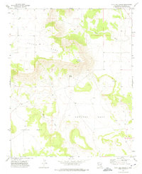
1972 Map of Punta Del Chorro
USGS Topo · Published 1975About this map
Antonio Ortiz and Preston Beck define the southern landscape of this San Miguel County region, where large land grants meet the distinctive high elevations of the Yegua Mesa. The topography is dominated by the namesake Punta del Chorro, a sharp promontory overlooking a network of ephemeral water sources. Life in this semi-arid environment centers on these vital points, including Chorro Spring, a simple Spring to the east, and the drainage of Corazon Creek. Near the northwestern corner, the Tuloso Cem provides a tangible link to the area's early residents. The land is marked by traditional property boundaries and cattle-country infrastructure, with Salitre Creek cutting through the lower sections of the survey.
Find a feature on this map
12 named features on this map. Tap any name to fly to it.
Don’t see what you’re looking for? This feature index may not catch every label — zoom into the map to look around manually.
Map Details
Editions of this 1972 Punta Del Chorro Map
This is the sole edition of this map. No revisions or reprints were ever made.
Other maps of this area

1892 · Watrous
USGS Topo · 1:125,000

1892 · Corazon
USGS Topo · 1:125,000

1894 · Corazon
USGS Topo · 1:125,000

1894 · Watrous
USGS Topo · 1:125,000

1954 · Santa Fe
USGS Topo · 1:250,000

1958 · Santa Fe
USGS Topo · 1:250,000

1963 · Cactus Tank
USGS Topo · 1:24,000

1963 · Flagstone Mountain
USGS Topo · 1:24,000

1971 · Laguna Huerfana
USGS Topo · 1:24,000

1971 · Trujillo
USGS Topo · 1:24,000