
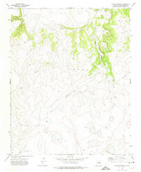
1971 Map of Trujillo
USGS Topo · Published 1975About this map
The settlement of Trujillo serves as the central hub of this northern New Mexico landscape, characterized by a complex network of canyons and high plateaus. Situated near a local Po and Cem, the village occupies a strategic position at the edge of significant terrain features like Corazon Hill. The geography is defined by deeply carved watercourses, including Cañon Largo, Cañon Ciruela, and Cañon Santiago, which dictate the local transportation routes and settlement patterns. To the southeast, the terrain descends toward Trementina Creek, while numerous smaller canyons such as Cañon Ventanas and Cañon Cuevas branch through the mesa country. This 1970s survey captures the region's ranching-oriented infrastructure, evidenced by isolated markers like the Water Tank and the persistence of small rural centers in San Miguel County.
Find a feature on this map
15 named features on this map. Tap any name to fly to it.
Don’t see what you’re looking for? This feature index may not catch every label — zoom into the map to look around manually.
Map Details
Editions of this 1971 Trujillo Map
This is the sole edition of this map. No revisions or reprints were ever made.
Other maps of this area

1892 · Watrous
USGS Topo · 1:125,000

1892 · Corazon
USGS Topo · 1:125,000

1894 · Corazon
USGS Topo · 1:125,000

1894 · Watrous
USGS Topo · 1:125,000

1954 · Santa Fe
USGS Topo · 1:250,000

1958 · Santa Fe
USGS Topo · 1:250,000

1963 · Flagstone Mountain
USGS Topo · 1:24,000

1971 · Laguna Huerfana
USGS Topo · 1:24,000
1971 · Canon Pedroso
USGS Topo · 1:24,000

1971 · Canon Olguin
USGS Topo · 1:24,000