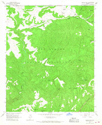
1966 Map of Cibecue Peak
USGS Topo · Published 1968About this map
The Fort Apache Indian Reservation landscape is defined by a dense network of drainages and high-elevation relief in Gila County. This mid-1960s topographic survey highlights the essential role of water management in the region, with numerous named tanks and springs peppered across the complex terrain. Significant water sources such as Jackrabbit Tank, Turkey Roost Tank, and the uniquely named Wool Cutter Spring point to the area's use for livestock or wildlife, even in the higher reaches of Cibecue Canyon. The map records a system of remote transit, including several Jeep Trails and unnamed trails that navigate the steep divides between Indian Canyon and Fox Canyon. The naming of features like Cowboy Spring and Horse Spring suggests a history of range activity and traditional land use within the reservation during the mid-twentieth century.
Find a feature on this map
35 named features on this map. Tap any name to fly to it.
Don’t see what you’re looking for? This feature index may not catch every label — zoom into the map to look around manually.
Map Details
Editions of this 1966 Cibecue Peak Map
This is the sole edition of this map. No revisions or reprints were ever made.
Other maps of this area

1886 · Holbrook
USGS Topo · 1:250,000

1893 · Holbrook
USGS Topo · 1:250,000

1922 · Chrysotile
USGS Topo · 1:125,000

1946 · Blue House Mtn
USGS Topo · 1:62,500

1951 · Blue House Mtn
USGS Topo · 1:62,500

1954 · Holbrook
USGS Topo · 1:250,000

1954 · Mesa
USGS Topo · 1:250,000

1957 · Mesa
USGS Topo · 1:250,000

1957 · Holbrook
USGS Topo · 1:250,000

1958 · Mesa
USGS Topo · 1:250,000