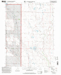
1997 Map of Hereford Se
USGS Topo · Published 2000About this map
Pawnee National Grassland dominates this high plains landscape in northern Weld County, where the topography is defined by the ephemeral drainages of Little Crow Creek and Crow Creek. The 1997 revision by the USDA Forest Service documents an arid region primarily utilized for ranching and resource extraction, characterized by a network of water management features and isolated infrastructure. Family-named landmarks such as McKay Windmill, Osborn Well, and Porter Well indicate the critical importance of groundwater access across these tracts. A small Landing Strip and several pipelines crossing the territory suggest specialized transport and energy utility within the grassland boundaries. To the north, Willow Creek and the small settlement of Wells provide additional points of reference in this sparsely populated corner of the Colorado plains.
Find a feature on this map
14 named features on this map. Tap any name to fly to it.
Don’t see what you’re looking for? This feature index may not catch every label — zoom into the map to look around manually.
Map Details
Editions of this 1997 Hereford Se Map
This is the sole edition of this map. No revisions or reprints were ever made.
Other maps of this area

1954 · Greeley
USGS Topo · 1:250,000

1957 · Greeley
USGS Topo · 1:250,000

1958 · Greeley
USGS Topo · 1:250,000

1961 · Greeley
USGS Topo · 1:250,000

1964 · Greeley
USGS Topo · 1:250,000

1965 · Greeley
USGS Topo · 1:250,000
1972 · Grover North
USGS Topo · 1:24,000

1972 · Briggsdale
USGS Topo · 1:24,000

1972 · Keota NW
USGS Topo · 1:24,000
1972 · Reno Reservoir
USGS Topo · 1:24,000