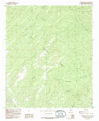
1985 Map of Hendricks Peak
USGS Topo · Published 1985About this map
Gila National Forest encompasses the vast majority of this landscape in the mid-1980s, defined by a complex network of canyons and high-elevation mesas. The southern reach of the Black Range is punctuated by Hendricks Peak and the unique formation of City of Rocks, while the Mimbres River and its East Fork provide the primary drainage system. Water is a vital element in this arid environment, evidenced by numerous named sources such as Trap Spring, Yates Spring, and Valentine Spring. The terrain transitions from the high Powderhorn Mesa down through steeply incised features like Powderhorn Canyon and Quaking Aspen Canyon. Local topography is further marked by Mud Springs Mountain and the open space of Rabb Park, providing a detailed look at the backcountry geography before modern digital updates.
Find a feature on this map
33 named features on this map. Tap any name to fly to it.
Don’t see what you’re looking for? This feature index may not catch every label — zoom into the map to look around manually.
Map Details
Editions of this 1985 Hendricks Peak Map
This is the sole edition of this map. No revisions or reprints were ever made.
Other maps of this area

1909 · Silver City
USGS Topo · 1:125,000

1911 · Alum Mountain
USGS Topo · 1:125,000

1913 · Alum Mountain
USGS Topo · 1:125,000

1937 · Santa Rita
USGS Topo · 1:24,000

1947 · Allie Canyon
USGS Topo · 1:24,000

1948 · Santa Rita
USGS Topo · 1:24,000

1948 · Allie Canyon
USGS Topo · 1:24,000
1951 · Santa Rita
USGS Topo · 1:24,000

1954 · Tularosa
USGS Topo · 1:250,000

1954 · Silver City
USGS Topo · 1:250,000