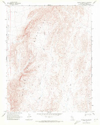
1969 Map of Wildcat Wash NE
USGS Topo · Published 1972About this map
Coyote Spring Valley and Meadow Valley define the arid landscape of Lincoln County in this late-1960s topographic survey. The terrain is dominated by unnamed mountain peaks and ridges, where drainage patterns are etched by the winding course of Wildcat Wash and Farrier Wash. These ephemeral watercourses descend toward the Bunker Hills, illustrating the stark hydrology of the Nevada desert. Human impact is minimal on this sheet, marked primarily by a single Jeep Trail that skirts the northwestern boundary. This 1969 field-checked record captures the region's wilderness character before modern development or major infrastructure altered these remote basins, providing a clear view of the natural topography and primitive access routes used by early surveyors and explorers.
Find a feature on this map
7 named features on this map. Tap any name to fly to it.
Don’t see what you’re looking for? This feature index may not catch every label — zoom into the map to look around manually.
Map Details
Editions of this 1969 Wildcat Wash NE Map
2 editions found
Other maps of this area

1885 · Pioche
USGS Topo · 1:250,000

1886 · Saint Thomas
USGS Topo · 1:250,000

1886 · Pioche
USGS Topo · 1:250,000

1893 · Saint Thomas
USGS Topo · 1:250,000

1954 · Caliente
USGS Topo · 1:250,000

1954 · Las Vegas
USGS Topo · 1:250,000

1957 · Las Vegas
USGS Topo · 1:250,000

1959 · Caliente
USGS Topo · 1:250,000

1959 · Las Vegas
USGS Topo · 1:250,000

1962 · Las Vegas
USGS Topo · 1:250,000