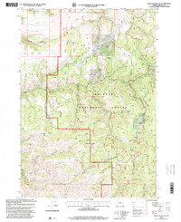
1998 Map of Graylock Butte
USGS Topo · Published 2000About this map
Malheur National Forest dominates the landscape of this Grant County survey, revised in the late 1990s. The topography is defined by high-elevation points such as Graylock Butte and Big Baldy, with the South Fork John Day River flowing through the southwestern corner. The map reveals an environment utilized for both natural preservation and resource extraction, evidenced by the presence of a Gravel Pit and Rock Pit near the eastern boundary.
Find a feature on this map
33 named features on this map. Tap any name to fly to it.
Don’t see what you’re looking for? This feature index may not catch every label — zoom into the map to look around manually.
Map Details
Editions of this 1998 Graylock Butte Map
This is the sole edition of this map. No revisions or reprints were ever made.
Other maps of this area

1932 · Dayville
USGS Topo · 1:125,000

1936 · Dayville
USGS Topo · 1:125,000

1940 · Aldrich Mtn.
USGS Topo · 1:62,500

1943 · Aldrich Mtn.
USGS Topo · 1:62,500

1955 · Canyon City
USGS Topo · 1:250,000

1959 · Canyon City
USGS Topo · 1:250,000

1961 · Izee
USGS Topo · 1:62,500

1972 · Big Weasel Sprs
USGS Topo · 1:24,000
1972 · Aldrich Gulch
USGS Topo · 1:24,000
1972 · Aldrich Mountain South
USGS Topo · 1:24,000