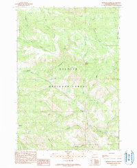
1990 Map of Johnson Saddle
USGS Topo · Published 1990About this map
Malheur National Forest provides the setting for this detailed look at a high-elevation drainage system in eastern Oregon. The terrain is defined by a dense network of watercourses, including the westward-flowing Wiley Creek, Cottonwood Creek, and Beech Creek. These waterways carve through the landscape, eventually converging toward the Blue Mountains' southern foothills. At the heart of this area, Johnson Saddle serves as a prominent geographic divide between the various creek basins.
Find a feature on this map
24 named features on this map. Tap any name to fly to it.
Don’t see what you’re looking for? This feature index may not catch every label — zoom into the map to look around manually.
Map Details
Editions of this 1990 Johnson Saddle Map
This is the sole edition of this map. No revisions or reprints were ever made.
Other maps of this area

1940 · Mount Vernon
USGS Topo · 1:62,500

1940 · John Day
USGS Topo · 1:62,500

1943 · John Day
USGS Topo · 1:62,500

1943 · Mount Vernon
USGS Topo · 1:62,500

1949 · Long Creek
USGS Topo · 1:62,500

1949 · Susanville
USGS Topo · 1:62,500

1951 · Susanville
USGS Topo · 1:62,500

1951 · Long Creek
USGS Topo · 1:62,500

1955 · Canyon City
USGS Topo · 1:250,000

1959 · Canyon City
USGS Topo · 1:250,000