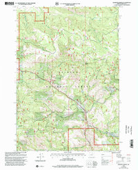
1999 Map of Johnson Saddle
USGS Topo · Published 2002About this map
The Malheur National Forest dominates this Grant County landscape, where the confluence of several mountain drainages forms a complex network of canyons and high ridges. The settlement of Raddue sits near the center of the sheet, positioned along Cottonwood Creek just south of the Cottonwood Campground. The map preserves the location of Mountain Rest (Site), an indicator of former activity or structural remains within the national forest boundaries.
Find a feature on this map
25 named features on this map. Tap any name to fly to it.
Don’t see what you’re looking for? This feature index may not catch every label — zoom into the map to look around manually.
Map Details
Editions of this 1999 Johnson Saddle Map
This is the sole edition of this map. No revisions or reprints were ever made.
Other maps of this area

1940 · Mount Vernon
USGS Topo · 1:62,500

1940 · John Day
USGS Topo · 1:62,500

1943 · John Day
USGS Topo · 1:62,500

1943 · Mount Vernon
USGS Topo · 1:62,500

1949 · Long Creek
USGS Topo · 1:62,500

1949 · Susanville
USGS Topo · 1:62,500

1951 · Susanville
USGS Topo · 1:62,500

1951 · Long Creek
USGS Topo · 1:62,500

1955 · Canyon City
USGS Topo · 1:250,000

1959 · Canyon City
USGS Topo · 1:250,000