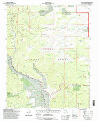
1995 Map of Mule Canyon
USGS Topo · Published 1998About this map
The Carson National Forest landscape in northern New Mexico is defined by a dense network of water tanks and high-altitude relief. Central to this map is the Tusas Ridge, which runs alongside Loco Ridge, separating deep drainages like Mule Canyon and Martinez Canyon. The distribution of over two dozen livestock tanks, including Bicara Tank and Mesa Tank, reflects the importance of managed water resources for grazing within the national forest system. Evidence of local history and human presence is marked by the Tusas Cem and scattered prospects near the eastern canyons. Water sources like Barela Spring and the drainage of Guido Canyon highlight the complex topography that defines this section of Rio Arriba County. The mapping also reveals a system of gulches, notably Cunningham Gulch and Sawmill Gulch, that feed into the larger canyon systems of the high desert plateau.
Find a feature on this map
78 named features on this map. Tap any name to fly to it.
Don’t see what you’re looking for? This feature index may not catch every label — zoom into the map to look around manually.
Map Details
Editions of this 1995 Mule Canyon Map
This is the sole edition of this map. No revisions or reprints were ever made.
Other maps of this area

1918 · Tusas
USGS Topo · 1:125,000

1954 · Raton
USGS Topo · 1:250,000

1954 · Aztec
USGS Topo · 1:250,000

1958 · Raton
USGS Topo · 1:250,000

1958 · Aztec
USGS Topo · 1:250,000

1962 · Aztec
USGS Topo · 1:250,000
1963 · Las Tablas
USGS Topo · 1:24,000

1963 · Broke Off Mountain
USGS Topo · 1:24,000

1963 · Burned Mountain
USGS Topo · 1:24,000
1963 · La Segita Peaks
USGS Topo · 1:24,000