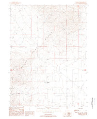
1988 Map of Paradise Well
USGS Topo · Published 1989About this map
The Santa Rosa Range and the Bloody Run Hills converge in this arid section of Humboldt County, framing a landscape defined by industrial extraction and sparse high-desert settlement. A network of 4wd tracks and a major Pipeline cross the valley floor, connecting the small community at Paradise Hill and its nearby Trailer Park to the surrounding terrain. Evidence of the region’s mineral history is visible throughout the slopes, marked by numerous Prospects, an Adit, and several Borrow Pits near the roadway. Water, the most critical resource in this environment, is pinpointed at Paradise Well and various isolated tanks and springs like those along Tony Creek. This 1980s survey captures the intersection of traditional mining interests and the modern infrastructure required to sustain life in the Nevada basin-and-range country.
Find a feature on this map
22 named features on this map. Tap any name to fly to it.
Don’t see what you’re looking for? This feature index may not catch every label — zoom into the map to look around manually.
Map Details
Editions of this 1988 Paradise Well Map
This is the sole edition of this map. No revisions or reprints were ever made.
Other maps of this area

1882 · Paradise
USGS Topo · 1:250,000

1893 · Paradise
USGS Topo · 1:250,000

1955 · McDermitt
USGS Topo · 1:250,000

1958 · Paradise Valley
USGS Topo · 1:62,500

1958 · Awakening Peak
USGS Topo · 1:62,500

1959 · McDermitt
USGS Topo · 1:250,000

1959 · Bliss
USGS Topo · 1:62,500
1982 · Andorno Ranch
USGS Topo · 1:24,000
1982 · Bloody Run Peak
USGS Topo · 1:24,000
1982 · Mud Spring Canyon
USGS Topo · 1:24,000