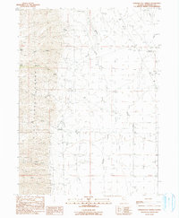
1990 Map of Howard Hot Spring
USGS Topo · Published 1990About this map
The Pine Forest Range dominates the western landscape of this 1990 survey, where steep terrain gives way to the high desert flats of Humboldt County. At the mountain front, Big Creek Ranch marks a point of human settlement where Big Creek emerges from the heights. The area is defined by its water sources, from the geothermal Howard Hot Spring in the northeast to scattered points like Willow Spring and the Four Springs group. Evidence of mineral exploration is visible along the southern slopes, with multiple noted Prospects and a Mine located near the headwaters of Granite Creek. The map documents a landscape of remote ranching and resource extraction, connected by a network of drainage systems including Rattlesnake Cr and Boyd Creek, illustrating the vital relationship between the rugged peaks and the arid basins below.
Find a feature on this map
21 named features on this map. Tap any name to fly to it.
Don’t see what you’re looking for? This feature index may not catch every label — zoom into the map to look around manually.
Map Details
Editions of this 1990 Howard Hot Spring Map
This is the sole edition of this map. No revisions or reprints were ever made.
Other maps of this area

1886 · Disaster
USGS Topo · 1:250,000

1893 · Disaster
USGS Topo · 1:250,000

1954 · Vya
USGS Topo · 1:250,000

1958 · Vya
USGS Topo · 1:250,000

1961 · Quinn River Crossing
USGS Topo · 1:62,500

1961 · Trident Peak
USGS Topo · 1:62,500

1962 · Vya
USGS Topo · 1:250,000

1965 · Duffer Peak
USGS Topo · 1:62,500

1966 · Denio
USGS Topo · 1:62,500

1979 · Denio
USGS Topo · 1:100,000