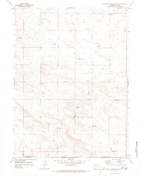
1970 Map of Cow Creek Reservoir SW
USGS Topo · Published 1973About this map
Kinney Rim dominates the western portion of this high-desert landscape, a prominent geological barrier that defines the local hydrology. This 1970s survey captures a territory straddling the Wyoming-Colorado border between Sweetwater County and Moffat County. The land is defined by an extensive network of small catchments and named pools such as Rocky Res, Forsaken Res, and High Center Res, reflecting the critical importance of water management for livestock ranching in this arid environment. Significant watercourses like Shell Creek and the meandering Crooked Wash cut through the terrain, while landmarks like Eagle Rock Draw and the Lower Shell Creek Crossing mark the paths used by ranchers and surveyors. This map preserves a specific moment in the land-use history of the borderlands, showing how ranching operations like the West Cow Creek Ranch Reservoir utilized the natural topography.
Find a feature on this map
21 named features on this map. Tap any name to fly to it.
Don’t see what you’re looking for? This feature index may not catch every label — zoom into the map to look around manually.
Map Details
Editions of this 1970 Cow Creek Reservoir SW Map
This is the sole edition of this map. No revisions or reprints were ever made.
Other maps of this area

1954 · Vernal
USGS Topo · 1:250,000

1954 · Rock Springs
USGS Topo · 1:250,000

1958 · Vernal
USGS Topo · 1:250,000

1958 · Rock Springs
USGS Topo · 1:250,000

1960 · Vernal
USGS Topo · 1:250,000

1962 · Rock Springs
USGS Topo · 1:250,000

1966 · Hiawatha
USGS Topo · 1:24,000

1968 · Chicken Creek East
USGS Topo · 1:24,000
1968 · Chicken Creek SE
USGS Topo · 1:24,000

1969 · Coffeepot Spring
USGS Topo · 1:24,000