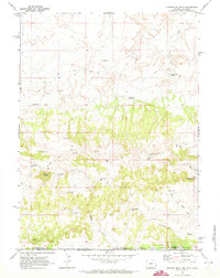
1970 Map of Powder Mountain
USGS Topo · Published 1973About this map
Powder Rim cuts across this high-desert landscape on the Wyoming-Colorado border, serving as a dramatic geographic boundary between the drainages of Grindstone Wash and Anthill Draw. The presence of the Cherokee Trail and various segments of Stock Trail indicate the historical importance of this corridor for movement through the high sagebrush country. This 1970 field-checked survey reveals a landscape heavily managed for livestock and resource extraction, punctuated by numerous catchments such as NW Powder Res, Salt Lick Res, and Sand Res.
Find a feature on this map
35 named features on this map. Tap any name to fly to it.
Don’t see what you’re looking for? This feature index may not catch every label — zoom into the map to look around manually.
Map Details
Editions of this 1970 Powder Mountain Map
This is the sole edition of this map. No revisions or reprints were ever made.
Other maps of this area

1954 · Vernal
USGS Topo · 1:250,000

1954 · Rock Springs
USGS Topo · 1:250,000

1958 · Vernal
USGS Topo · 1:250,000

1958 · Rock Springs
USGS Topo · 1:250,000

1960 · Vernal
USGS Topo · 1:250,000

1962 · Rock Springs
USGS Topo · 1:250,000

1969 · Reservoir Draw
USGS Topo · 1:24,000
1969 · The Nipple NE
USGS Topo · 1:24,000

1969 · Powder Wash
USGS Topo · 1:24,000

1970 · Prehistoric Rim
USGS Topo · 1:24,000