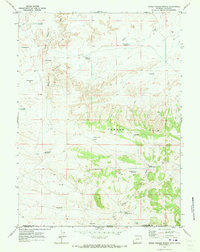
1970 Map of Upper Powder Spring
USGS Topo · Published 1973About this map
Powder Rim dominates this high-desert landscape along the state line, providing a massive topographical barrier between the drainage basins of the north and south. The map reveals an arid environment heavily modified by livestock and resource management, evidenced by the proliferation of earthen tanks such as Miserable Res, Haystack Res, and Last Res. Water, the defining constraint of the region, is captured in these scattered reservoirs along Skull Creek and Shell Creek, supporting a land use pattern of seasonal grazing and early energy exploration.
Find a feature on this map
29 named features on this map. Tap any name to fly to it.
Don’t see what you’re looking for? This feature index may not catch every label — zoom into the map to look around manually.
Map Details
Editions of this 1970 Upper Powder Spring Map
This is the sole edition of this map. No revisions or reprints were ever made.
Other maps of this area

1954 · Vernal
USGS Topo · 1:250,000

1954 · Rock Springs
USGS Topo · 1:250,000

1958 · Vernal
USGS Topo · 1:250,000

1958 · Rock Springs
USGS Topo · 1:250,000

1960 · Vernal
USGS Topo · 1:250,000

1962 · Rock Springs
USGS Topo · 1:250,000

1969 · Reservoir Draw
USGS Topo · 1:24,000

1969 · Coffeepot Spring
USGS Topo · 1:24,000

1969 · Powder Wash
USGS Topo · 1:24,000

1970 · Cow Creek Reservoir
USGS Topo · 1:24,000