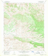
1968 Map of Jerusalem Mtn.
USGS Topo · Published 1971About this map
Jerusalem Mtn dominates this high-desert landscape in Pinal County, where complex geological formations created the distinctive Granite Basin and Reed Basin. The 1968 field survey reveals an area defined by deep drainage systems like McDougal Wash and Rattlesnake Canyon, which cut through the elevated flats of Poverty Flat and The Tablelands. Human activity in this remote region is centered around isolated landmarks such as the Lower Coalfield Mine and Mingo Rancho. Archaeological and ranching history is evidenced by the presence of Rockhouse Ruins near Rockhouse Spring, while numerous water sources like Walker Springs and Lime Spring provided essential stopover points for those navigating the Jeep Trail networks that connect these canyons and peaks.
Find a feature on this map
33 named features on this map. Tap any name to fly to it.
Don’t see what you’re looking for? This feature index may not catch every label — zoom into the map to look around manually.
Map Details
Editions of this 1968 Jerusalem Mtn. Map
This is the sole edition of this map. No revisions or reprints were ever made.
Other maps of this area

1911 · Winkelman
USGS Topo · 1:125,000

1913 · Winkelman
USGS Topo · 1:125,000

1915 · Christmas
USGS Topo · 1:62,500

1917 · Christmas
USGS Topo · 1:62,500

1938 · Klondyke
USGS Topo · 1:48,000

1943 · Klondyke
USGS Topo · 1:62,500

1949 · Holy Joe Peak
USGS Topo · 1:62,500

1949 · Saddle Mtn.
USGS Topo · 1:24,000

1949 · Brandenburg Mtn
USGS Topo · 1:24,000
1950 · Saddle Mtn.
USGS Topo · 1:24,000