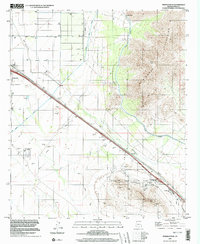
1996 Map of Newman Peak
USGS Topo · Published 2003About this map
The Picacho Mountains rise sharply above the desert floor, dominated by the towering heights of Newman Peak and Picacho Peak. This arid landscape is defined by the massive water infrastructure required for regional growth, specifically the massive Central Arizona Project Aqueduct and the Main Canal that cut across the valley floor. Near the junction of major transit corridors, the community of Picacho sits adjacent to the Picacho Peak State Park, where a dedicated Picnic Area and Mobile Home Park signify the area's role as a waypoint for travelers. Aviation history is noted by the Picacho Stagefield Control Tower (Heliport), while the numerous Borrow Pits scattered near the Picacho Peak Interchange reflect the intensive earth-moving required for modern highway and canal construction. Drainage patterns are governed by McClellan Wash, which carries seasonal runoff through the alluvial plains below the peaks.
Find a feature on this map
20 named features on this map. Tap any name to fly to it.
Don’t see what you’re looking for? This feature index may not catch every label — zoom into the map to look around manually.
Map Details
Editions of this 1996 Newman Peak Map
This is the sole edition of this map. No revisions or reprints were ever made.
Other maps of this area

1922 · Red Rock No 2
USGS Topo · 1:48,000

1922 · Signal Peak
USGS Topo · 1:62,500

1924 · Signal Peak
USGS Topo · 1:62,500

1934 · Newman Peak
USGS Topo · 1:125,000

1947 · Red Rock
USGS Topo · 1:62,500

1947 · Eloy
USGS Topo · 1:62,500

1948 · Eloy
USGS Topo · 1:62,500

1956 · Tucson
USGS Topo · 1:250,000

1958 · Tucson
USGS Topo · 1:250,000

1959 · Tucson
USGS Topo · 1:250,000