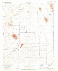
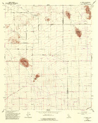
1956 Map of El Mirage
USGS Topo · Published 1969About this map
El Mirage Valley straddles the county line between Los Angeles and San Bernardino, characterized by a desert landscape of isolated buttes and seasonal water sources. The 1968 revisions, indicated in purple, highlight a shift toward infrastructure development, including numerous newly mapped reservoirs and the prominent Pearblossom Hy. A historical aviation footprint is visible at the Gray Butte 36 Field (Abandoned), which contrasts with the active industrial activity indicated by several quarries and prospects near Mt Elmo and Black Mtn. In the southern portion of the quadrangle, the Southern Pacific railroad corridor cuts across the terrain near the Three Sisters peaks. For local historians and genealogists, the map preserves the locations of early water points like Moody Springs and the small settlement of El Mirage during a period of expanding road networks like Palmdale Boulevard.
Find a feature on this map
23 named features on this map. Tap any name to fly to it.
Don’t see what you’re looking for? This feature index may not catch every label — zoom into the map to look around manually.
Map Details
Editions of this 1956 El Mirage Map
5 editions found
Other maps of this area

1901 · Southern California Sheet No. 1
USGS Topo · 1:250,000

1903 · Rock Creek
USGS Topo · 1:62,500

1903 · San Antonio
USGS Topo · 1:62,500

1904 · Southern California Sheet No. 1
USGS Topo · 1:250,000

1930 · Black Butte
USGS Topo · 1:24,000

1930 · El Mirage
USGS Topo · 1:24,000

1930 · Angle
USGS Topo · 1:24,000

1930 · Wilsona
USGS Topo · 1:24,000

1932 · Angle
USGS Topo · 1:24,000

1933 · El Mirage
USGS Topo · 1:24,000