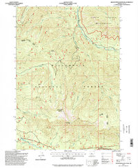
1997 Map of Grasshopper Mountain
USGS Topo · Published 1998About this map
Grasshopper Mountain and Grasshopper Point dominate the central landscape of this section of the Willamette National Forest, where steep drainages define the hydrology of Lane County. The South Fork McKenzie River winds through the northeast, while the North Fork Middle Fork Willamette River follows the southern boundary alongside the Robert Aufderheide Memorial Dr. This 1990s survey illustrates a heavily managed forest environment, marked by numerous quarries and a complex network of forest roads. The presence of a Homestead near the South Fork McKenzie River provides a specific point of interest for local historians, situated between the protected boundaries of the Three Sisters Wilderness and the Waldo Lake Wilderness. The terrain transitions from the high elevations of Hiyu Ridge and Hardy Ridge down into deep creek basins like Augusta Creek and Hardy Creek.
Find a feature on this map
41 named features on this map. Tap any name to fly to it.
Don’t see what you’re looking for? This feature index may not catch every label — zoom into the map to look around manually.
Map Details
Editions of this 1997 Grasshopper Mountain Map
This is the sole edition of this map. No revisions or reprints were ever made.
Other maps of this area

1925 · Waldo Lake
USGS Topo · 1:125,000

1934 · Mc Kenzie Bridge
USGS Topo · 1:96,000

1940 · Mc Kenzie Bridge
USGS Topo · 1:125,000

1953 · Salem
USGS Topo · 1:250,000

1954 · Salem
USGS Topo · 1:250,000

1955 · Chucksney Mtn
USGS Topo · 1:62,500

1955 · Blue River
USGS Topo · 1:62,500

1955 · Mc Kenzie Bridge
USGS Topo · 1:62,500

1956 · Sardine Butte
USGS Topo · 1:62,500

1958 · Roseburg
USGS Topo · 1:250,000