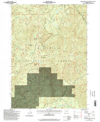
1997 Map of Groundhog Mountain
USGS Topo · Published 1998About this map
The Willamette National Forest dominates this topographic survey of the Cascades, where steep peaks and timbered ridges define the drainage of the Middle Fork Willamette River. High-altitude landmarks like the Warner Mountain Lookout and Logger Butte provide vantage points over a complex network of forest roads and resource extraction sites, including numerous quarries and gravel pits. The geography is characterized by prominent elevations such as Groundhog Mountain and Buck Mountain, with drainage provided by the South Fork Groundhog Creek and North Fork Buck Creek. The map documents a landscape of industrial forestry, evidenced by the named ridges and basins like Juniper Ridge and Joes Prairie, alongside small water bodies such as Waterdog Lake.
Find a feature on this map
40 named features on this map. Tap any name to fly to it.
Don’t see what you’re looking for? This feature index may not catch every label — zoom into the map to look around manually.
Map Details
Editions of this 1997 Groundhog Mountain Map
This is the sole edition of this map. No revisions or reprints were ever made.
Other maps of this area

1917 · Diamond Lake
USGS Topo · 1:125,000

1925 · Waldo Lake
USGS Topo · 1:125,000

1956 · Toketee Falls
USGS Topo · 1:62,500

1956 · Waldo Lake
USGS Topo · 1:62,500

1956 · Summit Lake
USGS Topo · 1:62,500

1956 · Oakridge
USGS Topo · 1:62,500

1958 · Roseburg
USGS Topo · 1:250,000

1959 · Roseburg
USGS Topo · 1:250,000

1978 · Diamond Lake
USGS Topo · 1:100,000

1983 · Oakridge
USGS Topo · 1:100,000