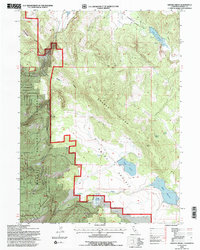
1993 Map of Graven Ridge
USGS Topo · Published 1996About this map
Graven Ridge dominates this northern California landscape, which was revised by the U.S. Forest Service in the early 1990s. The area is characterized by a complex network of upland water management and seasonal grazing grounds, centered on significant catchments like Graves Reservoir, Graven Reservoir, and Bayley Reservoir. These water sources are vital to the high-country ecology and the managed lands of the Modoc National Forest. Geologically, the terrain transitions from the high elevations of Portuguese Ridge down toward the wide expanse of Rocky Prairie. The map captures an environment defined by its hydrology, including numerous named seeps such as Arnett Spring and Higgins Spring, alongside intermittent drainages like Hilton Creek. The prevalence of four-wheel-drive tracks suggests a landscape primarily accessed for forestry operations and seasonal resource management rather than permanent settlement.
Find a feature on this map
18 named features on this map. Tap any name to fly to it.
Don’t see what you’re looking for? This feature index may not catch every label — zoom into the map to look around manually.
Map Details
Editions of this 1993 Graven Ridge Map
This is the sole edition of this map. No revisions or reprints were ever made.
Other maps of this area

1886 · Alturas
USGS Topo · 1:250,000

1892 · Alturas
USGS Topo · 1:250,000

1954 · Alturas
USGS Topo · 1:250,000

1958 · Alturas
USGS Topo · 1:250,000

1961 · Canby
USGS Topo · 1:62,500

1961 · Alturas
USGS Topo · 1:62,500

1962 · Alturas
USGS Topo · 1:250,000
1962 · Adin
USGS Topo · 1:62,500

1962 · Likely
USGS Topo · 1:62,500

1965 · Alturas
USGS Topo · 1:250,000