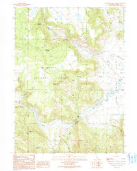
1990 Map of Washington Mountain
USGS Topo · Published 1990About this map
The Pit River cuts through this high-desert landscape in northeastern California, where the Warm Springs Valley meets the timbered slopes of the Modoc National Forest. This late-twentieth-century record shows the area just as modern accessibility began to intersect with long-standing ranching and forest uses. Key landmarks include the Canby Bridge crossing and the Howards Gulch Campground, providing a look at the outdoor recreation infrastructure of the era. The terrain is defined by prominent volcanic features such as Washington Mountain and Westlake Butte, alongside isolated landmarks like City Rock. Evidence of local industry and resource extraction is visible in the various Borrow Pits and a Cinder Pit scattered across the quadrangle, while seasonal water sources like Gosch Spring reveal the hydrology critical to this arid environment.
Find a feature on this map
23 named features on this map. Tap any name to fly to it.
Don’t see what you’re looking for? This feature index may not catch every label — zoom into the map to look around manually.
Map Details
Editions of this 1990 Washington Mountain Map
This is the sole edition of this map. No revisions or reprints were ever made.
Other maps of this area

1886 · Alturas
USGS Topo · 1:250,000

1886 · Modoc Lava Bed
USGS Topo · 1:250,000

1892 · Modoc Lava-Bed
USGS Topo · 1:250,000

1892 · Alturas
USGS Topo · 1:250,000

1952 · Hackamore
USGS Topo · 1:62,500

1954 · Alturas
USGS Topo · 1:250,000

1958 · Alturas
USGS Topo · 1:250,000

1961 · Canby
USGS Topo · 1:62,500

1962 · Alturas
USGS Topo · 1:250,000

1962 · Crank Mountain
USGS Topo · 1:62,500