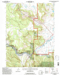
1993 Map of Washington Mountain
USGS Topo · Published 1996About this map
Pit River winds through the southern reaches of this landscape, carving a path through the volcanic terrain of the Modoc National Forest. The geography is defined by a transition from the elevated peaks of Washington Mountain and Westlake Butte down into the broader flats of Garden Valley and Warm Springs Valley. In the early 1990s, when these revisions were field-checked, the area maintained a rugged character dominated by drainage gulches like Howards Gulch and Shake Canyon. Human presence is sparse but concentrated along the water, visible at the Canby Bridge and the Gaging Station on the river. The abundance of named water sources, such as Gosch Spring and Westlake, suggests the critical importance of these springs to local ranching and forest management in a region otherwise marked by seasonal aridity and deep canyons.
Find a feature on this map
32 named features on this map. Tap any name to fly to it.
Don’t see what you’re looking for? This feature index may not catch every label — zoom into the map to look around manually.
Map Details
Editions of this 1993 Washington Mountain Map
This is the sole edition of this map. No revisions or reprints were ever made.
Other maps of this area

1886 · Alturas
USGS Topo · 1:250,000

1886 · Modoc Lava Bed
USGS Topo · 1:250,000

1892 · Modoc Lava-Bed
USGS Topo · 1:250,000

1892 · Alturas
USGS Topo · 1:250,000

1952 · Hackamore
USGS Topo · 1:62,500

1954 · Alturas
USGS Topo · 1:250,000

1958 · Alturas
USGS Topo · 1:250,000

1961 · Canby
USGS Topo · 1:62,500

1962 · Alturas
USGS Topo · 1:250,000

1962 · Crank Mountain
USGS Topo · 1:62,500