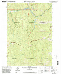
1998 Map of Henderson Ridge
USGS Topo · Published 2002About this map
Henderson Ridge serves as a prominent landmark in this late-twentieth-century study of the boundary lands between Idaho and Montana. The map reveals a landscape defined by its resource extraction history, most notably at the Taylor Creek Mine where tailings and mines are clearly marked along the northern drainages. This high-elevation terrain is divided between the Bitterroot National Forest and Salmon National Forest, with the state line tracing the continental divide. Small-scale human markers such as the Handerson Cabin and various adits underscore the isolated nature of the region. A complex network of water features, including Hughes Creek, McConn Creek, and several remote springs like Tincan Spring and Grizzly Spring, provide the primary orientation points for this mountainous corridor. The presence of the Corral Trail and unnamed trails suggests a continued use of the land for recreation and forest management long after the initial mining booms.
Find a feature on this map
34 named features on this map. Tap any name to fly to it.
Don’t see what you’re looking for? This feature index may not catch every label — zoom into the map to look around manually.
Map Details
Editions of this 1998 Henderson Ridge Map
This is the sole edition of this map. No revisions or reprints were ever made.
Other maps of this area

1956 · Elk City
USGS Topo · 1:250,000

1960 · Elk City
USGS Topo · 1:250,000

1960 · Painted Rocks Lake
USGS Topo · 1:62,500

1960 · Ulysses Mtn
USGS Topo · 1:62,500

1960 · Shoup
USGS Topo · 1:62,500

1960 · Piquett Mountain
USGS Topo · 1:62,500

1982 · Bighorn Crags
USGS Topo · 1:100,000
1991 · Piquett Mountain
USGS Topo · 1:24,000
1991 · Henderson Ridge
USGS Topo · 1:24,000
1991 · Ulysses Mountain
USGS Topo · 1:24,000