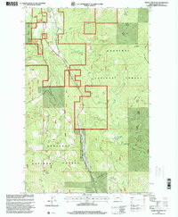
1997 Map of Horse Mountain
USGS Topo · Published 2000About this map
Kootenai National Forest dominates this section of Lincoln County, where the topography is defined by the high crests of Horse Mountain and Brush Mountain. The landscape is a network of drainage basins, with Libby Creek and Swamp Creek carving significant valleys through the terrain. A notable feature of the late 20th-century forest management era is the Landing Strip situated along the Swamp Creek corridor, suggesting the importance of aerial access for fire control or forestry operations. The map also captures the Fisher River Ranger District boundary and named landmarks like Paul Bunyan and Hoodoo Hill. The presence of the Fisher Mountain Trail and various unpaved routes reveals how the timber and recreation economy utilized the Libby Divide and the surrounding backcountry near Tepee Lake.
Find a feature on this map
29 named features on this map. Tap any name to fly to it.
Don’t see what you’re looking for? This feature index may not catch every label — zoom into the map to look around manually.
Map Details
Editions of this 1997 Horse Mountain Map
This is the sole edition of this map. No revisions or reprints were ever made.
Other maps of this area

1920 · Libby
USGS Topo · 1:125,000

1920 · Jennings
USGS Topo · 1:125,000

1930 · Libby
USGS Topo · 1:125,000

1932 · Libby
USGS Topo · 1:125,000

1935 · Thompson Lakes
USGS Topo · 1:96,000

1942 · Thompson Lakes
USGS Topo · 1:125,000

1957 · Kalispell
USGS Topo · 1:250,000

1960 · Kalispell
USGS Topo · 1:250,000

1961 · Kalispell
USGS Topo · 1:250,000

1963 · Swede Mountain
USGS Topo · 1:24,000