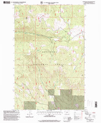
1997 Map of Warland Peak
USGS Topo · Published 2000About this map
Warland Peak dominates the northern reaches of this landscape, situated within the expansive Kootenai National Forest. Revised in the late 1990s, the terrain is defined by a dense network of high ridges and deep drainages, including the headwaters of Cripple Horse Creek and Dry Fork Creek. A prominent Lookout station is positioned atop the peak, overlooking a wilderness of significant relief. The hydrology of the area is intricately detailed, showing the convergence of Threemile Creek and East Fork, alongside numerous seasonal flows. To the south, Weigel Mountain and Wolf Point provide secondary high points, while Summit Spring offers a rare named water source amidst the steep elevations. The map reveals the Forest Service's management through a system of trails and unimproved roads that navigate the complex topography of the Lincoln County interior.
Find a feature on this map
13 named features on this map. Tap any name to fly to it.
Don’t see what you’re looking for? This feature index may not catch every label — zoom into the map to look around manually.
Map Details
Editions of this 1997 Warland Peak Map
This is the sole edition of this map. No revisions or reprints were ever made.
Other maps of this area

1913 · Stryker
USGS Topo · 1:125,000

1916 · Stryker
USGS Topo · 1:125,000

1920 · Jennings
USGS Topo · 1:125,000

1935 · Thompson Lakes
USGS Topo · 1:96,000

1942 · Thompson Lakes
USGS Topo · 1:125,000

1957 · Kalispell
USGS Topo · 1:250,000

1960 · Kalispell
USGS Topo · 1:250,000

1961 · Kalispell
USGS Topo · 1:250,000

1963 · Wolf Prairie
USGS Topo · 1:24,000

1963 · Davis Mountain
USGS Topo · 1:24,000