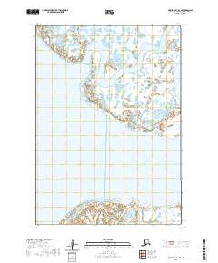
2020 Map of Hooper Bay A-1 SE
USGS Topo · Published 2020About this map
Naskonat Peninsula anchors the southern reaches of this landscape, where the coastal wetlands of the Yukon-Kuskokwim Delta meet the Bering Sea. This 2020 survey documents the intricate, water-dominant environment of the Kusilvak Census Area, defined by the slow-moving Anerkochik River as it winds northward through a network of ponds and saturated tundra. Further south, the Azun River cuts a path across the peninsula, illustrating the dynamic hydrology that shapes this remote portion of western Alaska. The lack of built infrastructure reflects the preservation of traditional land use patterns, providing a clear view of the natural drainage systems and seasonal waterways that are vital to the region's geography.
Find a feature on this map
7 named features on this map. Tap any name to fly to it.
Don’t see what you’re looking for? This feature index may not catch every label — zoom into the map to look around manually.
Map Details
Editions of this 2020 Hooper Bay A-1 SE Map
This is the sole edition of this map. No revisions or reprints were ever made.
Other maps of this area

1951 · Marshall
USGS Topo · 1:250,000

1951 · Hooper Bay
USGS Topo · 1:250,000

1951 · Nunivak Island
USGS Topo · 1:250,000

1951 · Baird Inlet
USGS Topo · 1:250,000

1953 · Hooper Bay
USGS Topo · 1:250,000

1954 · Nunivak Island
USGS Topo · 1:250,000
1954 · Marshall A-8
USGS Topo · 1:63,360

1954 · Marshall
USGS Topo · 1:250,000

1954 · Baird Inlet
USGS Topo · 1:250,000

1954 · Baird Inlet D-8
USGS Topo · 1:63,360